
File:Bellaghy Bawn - geograph.org.uk - 505234.jpg
No higher resolution available.
Bellaghy_Bawn_-_geograph.org.uk_-_505234.jpg (640 × 427 pixels, file size: 59 KB, MIME type: image/jpeg)
| This is a file from the Wikimedia Commons. Information from its description page there is shown below. Commons is a freely licensed media file repository. You can help. |
Summary
| Description |
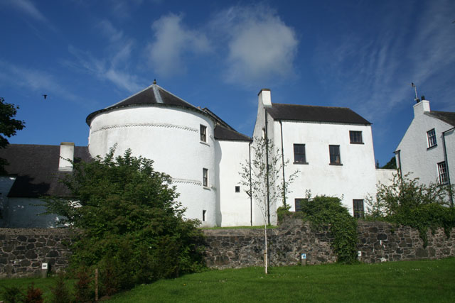
English: Bellaghy Bawn Marked as Bellaghy Castle on OS maps, this building is more correctly called a Bawn. A Bawn is a fortified house. This one was built as part of the Plantation of Ulster by the Vintners' Company of London who were granted the land around Bellaghy in 1619. It was intended as a place of refuge in times of trouble. The round tower in the photograph dates from at least 1622. |
| Date | |
| Source | From geograph.org.uk |
| Author | Cormac Duffin |
| Attribution (required by the license) | Cormac Duffin / Bellaghy Bawn / |
| Camera location | | View this and other nearby images on: OpenStreetMap |
|---|
_heading:270.00&language=en)
| Object location | | View this and other nearby images on: OpenStreetMap |
|---|
_heading:270.00&language=en)
Licensing

|
This image was taken from the Geograph project collection. See this photograph's page on the Geograph website for the photographer's contact details. The copyright on this image is owned by Cormac Duffin and is licensed for reuse under the Creative Commons Attribution-ShareAlike 2.0 license.
|
This file is licensed under the Creative Commons Attribution-Share Alike 2.0 Generic license.
Attribution: Cormac Duffin
- You are free:
- to share – to copy, distribute and transmit the work
- to remix – to adapt the work
- Under the following conditions:
- attribution – You must give appropriate credit, provide a link to the license, and indicate if changes were made. You may do so in any reasonable manner, but not in any way that suggests the licensor endorses you or your use.
- share alike – If you remix, transform, or build upon the material, you must distribute your contributions under the same or compatible license as the original.
File history
Click on a date/time to view the file as it appeared at that time.
| Date/Time | Thumbnail | Dimensions | User | Comment | |
|---|---|---|---|---|---|
| current | 07:44, 5 February 2011 | | 640 × 427 (59 KB) | GeographBot | == {{int:filedesc}} == {{Information |description={{en|1=Bellaghy Bawn Marked as Bellaghy Castle on OS maps, this building is more correctly called a Bawn. A Bawn is a fortified house. This one was built as part of the Plantation of Ulster by the Vintner |
File usage
The following pages on the English Wikipedia use this file (pages on other projects are not listed):
Global file usage
The following other wikis use this file:
- Usage on gd.wikipedia.org
- Usage on nl.wikipedia.org
- Usage on ru.wikipedia.org
- Usage on uk.wikipedia.org