
File:Bedfordshire UK location map.svg

Size of this PNG preview of this SVG file: 530 × 599 pixels. Other resolutions: 212 × 240 pixels | 425 × 480 pixels | 679 × 768 pixels | 906 × 1,024 pixels | 1,812 × 2,048 pixels | 1,120 × 1,266 pixels.
Original file (SVG file, nominally 1,120 × 1,266 pixels, file size: 1.34 MB)
| This is a file from the Wikimedia Commons. Information from its description page there is shown below. Commons is a freely licensed media file repository. You can help. |
| Description |
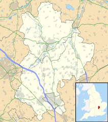
Map of Bedfordshire, UK with the following information shown:
Equirectangular map projection on WGS 84 datum, with N/S stretched 160% Geographic limits:
|
| Date | |
| Source |
|
| Author | Nilfanion, created using Ordnance Survey data |
| Permission (Reusing this file) |
This file is licensed under the Creative Commons Attribution-Share Alike 3.0 Unported license. Attribution: Contains Ordnance Survey data © Crown copyright and database right
|
| Other versions | File:Bedfordshire UK district map (blank).svg - Blank map with administrative borders only. |
.svg)
File history
Click on a date/time to view the file as it appeared at that time.
| Date/Time | Thumbnail | Dimensions | User | Comment | |
|---|---|---|---|---|---|
| current | 17:56, 26 September 2010 | | 1,120 × 1,266 (1.34 MB) | Nilfanion | Tweak m-ways .. again.. |
| 23:56, 6 September 2010 |  | 1,120 × 1,266 (1.34 MB) | Nilfanion | Tweaking urban areas, road colours and boundary lines | |
| 20:36, 4 September 2010 |  | 1,120 × 1,266 (1.29 MB) | Nilfanion | {{Information |Description=Map of Bedfordshire, UK with the following information shown: *Administrative borders *Coastline, lakes and rivers *Motorways, primary routes and A-roads *Urban areas Equirectangular map projection on WGS 84 |
File usage
More than 100 pages use this file. The following list shows the first 100 pages that use this file only. A full list is available.
- Ampthill
- Arlesey
- Aspley Guise
- Aspley Heath
- Astwick
- Barton-le-Clay
- Battlesden
- Bedford
- Beeston, Bedfordshire
- Biddenham
- Biggleswade
- Billington, Bedfordshire
- Bletsoe
- Blunham
- Bolnhurst
- Brickhill
- Brogborough
- Bromham, Bedfordshire
- Broom, Bedfordshire
- Bushmead Priory
- Caddington
- Campton, Bedfordshire
- Cardington, Bedfordshire
- Carlton, Bedfordshire
- Chalgrave
- Chalton, Bedfordshire
- Chicksands
- Civil parishes in Bedfordshire
- Clapham, Bedfordshire
- Cockayne Hatley
- Cranfield
- Cranfield Airport
- Eaton Bray
- Eggington
- Eggington House
- Eversholt
- Everton, Bedfordshire
- Farley Hill, Luton
- Farndish
- Felmersham
- Flitwick
- Forest of Marston Vale
- Great Barford
- Greenfield, Bedfordshire
- Harlington, Bedfordshire
- Haynes, Bedfordshire
- Heath and Reach
- Henlow
- Hockliffe
- Houghton House
- Houghton Regis
- Hundred of Biggleswade
- Kempston
- Kempston Hardwick
- Kempston Rural
- Leighton Buzzard
- Lidlington
- Limbury
- Linslade
- List of places in Bedfordshire
- Little Barford
- London Gliding Club
- Luton Airport
- Luton Airport Parkway railway station
- Luton Hoo
- Marston Moreteyne
- Maulden
- Millbrook, Bedfordshire
- Milton Ernest
- Odell, Bedfordshire
- Old Warden
- Pavenham
- Pertenhall
- Potton
- RAE Bedford
- RAF Chicksands
- RAF Henlow
- RAF Tempsford
- Ridgmont
- Sandy, Bedfordshire
- Sharnbrook
- Shefford, Bedfordshire
- Shillington, Bedfordshire
- Shuttleworth Collection
- Silsoe
- Southcote, Bedfordshire
- Stagsden
- Stewartby
- Stopsley
- Stotfold
- Studham
- Swineshead, Bedfordshire
- Turvey, Bedfordshire
- Warden Hill, Luton
- Westoning
- Woburn, Bedfordshire
- Woburn Sands
- Wootton, Bedfordshire
- Wrest Park
- Wyboston
View more links to this file.
Global file usage
The following other wikis use this file:
- Usage on af.wikipedia.org
- Usage on ar.wikipedia.org
- Usage on bg.wikipedia.org
- Usage on bn.wikipedia.org
- Usage on ceb.wikipedia.org
- Usage on es.wikipedia.org
- Bedford
- Aeropuerto de Londres-Luton
- Dunstable
- Luton
- Aley Green
- Honeydon
- Hinwick
- Plantilla:Mapa de localización de Bedfordshire
- Carlton (Bedfordshire)
- Bromham (Bedfordshire)
- Cotton End
- Milton Ernest
- Gibraltar (Bedfordshire)
- Great Barford
- Clapham (Bedfordshire)
- Cople
- Riseley
- Harrold
- Oakley (Bedfordshire)
- Sharnbrook
- Kempston
- Stevington
- Stewartby
- Wyboston
- Shortstown
- Wootton (Bedfordshire)
- Willington (Bedfordshire)
- Wilstead
- Thurleigh
- Turvey
- Wixams
- Ampthill
- Holywell (Bedfordshire)
- Dunton
- Everton (Bedfordshire)
- Houghton Conquest
- Houghton Regis
- Potton (Bedfordshire)
- Fairfield Park
- Greenfield / Flitton
- Eaton Bray
- Biggleswade
- Beeston (Bedfordshire)
View more global usage of this file.