
File:Beddarthur standing stone circle, Preseli Mountains - geograph.org.uk - 258436.jpg
No higher resolution available.
Beddarthur_standing_stone_circle,_Preseli_Mountains_-_geograph.org.uk_-_258436.jpg (640 × 480 pixels, file size: 44 KB, MIME type: image/jpeg)
| This is a file from the Wikimedia Commons. Information from its description page there is shown below. Commons is a freely licensed media file repository. You can help. |
Summary
| Description |
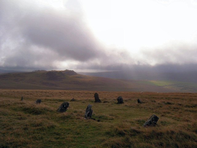
English: Beddarthur standing stone circle, Preseli Mountains The stone circle of Beddarthur lies on the north eastern slopes of Carn Siân in the Preseli Mountains, North Pembrokeshire. The stone circle is adjacent to the ancient trackway known as the 'Golden Road' which runs along the Preseli mountain ridge and passes Carn Menyn (the reputed source of the Stonehenge Bluestones) which can be seen in the distance. |
| Date | |
| Source | From geograph.org.uk |
| Author | Andrew Howey |
| Attribution (required by the license) | Andrew Howey / Beddarthur standing stone circle, Preseli Mountains / |
| Object location | | View this and other nearby images on: OpenStreetMap |
|---|
_heading:90.00&language=en)
Licensing

|
This image was taken from the Geograph project collection. See this photograph's page on the Geograph website for the photographer's contact details. The copyright on this image is owned by Andrew Howey and is licensed for reuse under the Creative Commons Attribution-ShareAlike 2.0 license.
|
This file is licensed under the Creative Commons Attribution-Share Alike 2.0 Generic license.
Attribution: Andrew Howey
- You are free:
- to share – to copy, distribute and transmit the work
- to remix – to adapt the work
- Under the following conditions:
- attribution – You must give appropriate credit, provide a link to the license, and indicate if changes were made. You may do so in any reasonable manner, but not in any way that suggests the licensor endorses you or your use.
- share alike – If you remix, transform, or build upon the material, you must distribute your contributions under the same or compatible license as the original.
File history
Click on a date/time to view the file as it appeared at that time.
| Date/Time | Thumbnail | Dimensions | User | Comment | |
|---|---|---|---|---|---|
| current | 16:37, 25 August 2010 | | 640 × 480 (44 KB) | GeographBot | == {{int:filedesc}} == {{Information |description={{en|1=Beddarthur standing stone circle, Preseli Mountains The stone circle of Beddarthur lies on the north eastern slopes of Carn Siân in the Preseli Mountains, North Pembrokeshire. The stone circle is a |
File usage
The following pages on the English Wikipedia use this file (pages on other projects are not listed):
Global file usage
The following other wikis use this file:
- Usage on ar.wikipedia.org
- Usage on bh.wikipedia.org
- Usage on br.wikipedia.org
- Usage on ca.wikipedia.org
- Usage on da.wikipedia.org
- Usage on de.wikipedia.org
- Usage on dty.wikipedia.org
- Usage on fa.wikipedia.org
- Usage on ilo.wikipedia.org
- Usage on lld.wikipedia.org
- Usage on mai.wikipedia.org
- Usage on ml.wikipedia.org
- Usage on ne.wikipedia.org
- Usage on pa.wikipedia.org
- Usage on simple.wikipedia.org
- Usage on si.wikipedia.org
- Usage on sl.wikipedia.org
- Usage on ta.wikipedia.org
- Usage on te.wikipedia.org
- Usage on th.wikipedia.org
- Usage on tum.wikipedia.org
- Usage on vi.wikipedia.org