
File:Battle of Damascus map.svg

Size of this PNG preview of this SVG file: 800 × 473 pixels. Other resolutions: 320 × 189 pixels | 640 × 378 pixels | 1,024 × 605 pixels | 1,280 × 756 pixels | 2,560 × 1,513 pixels | 1,335 × 789 pixels.
Original file (SVG file, nominally 1,335 × 789 pixels, file size: 212 KB)
| This is a file from the Wikimedia Commons. Information from its description page there is shown below. Commons is a freely licensed media file repository. You can help. |
Summary
| Description |
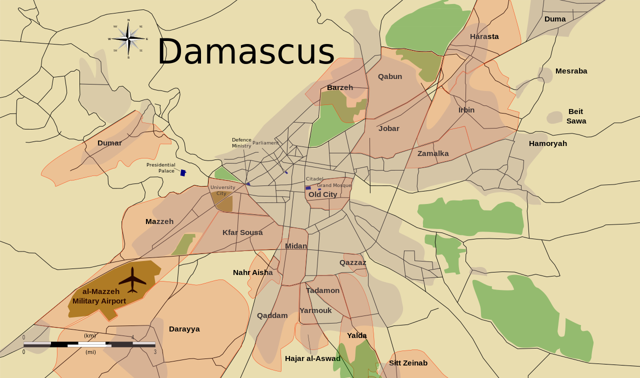
English: Situation in the city during the battle of Damascus. Red indicates a conflict area.
Based on information available from BBC News and using the same style as used by Rafy in his Battle of Tripoli map. Made in Inkscape. English: الوضع في مدينة دمشق خلال معركة دمشق. المناطق المظللة باللون الأحمر هي مناطق نزاع المعلومات التي تقدمها هذه الخريطة مبنية على المعلومات المتوفرة من بي بي سي نيوز و باستخدام نفس الأسلوب الذي استخدمه المستخدم Rafy في خريطة معركة طرابلس، التي أنشأها باستخدام برنامج انكسكيب. |
| Date | |
| Source | Own work |
| Author | MrPenguin20 |
Licensing
This file is licensed under the Creative Commons Attribution-Share Alike 3.0 Unported license.
- You are free:
- to share – to copy, distribute and transmit the work
- to remix – to adapt the work
- Under the following conditions:
- attribution – You must give appropriate credit, provide a link to the license, and indicate if changes were made. You may do so in any reasonable manner, but not in any way that suggests the licensor endorses you or your use.
- share alike – If you remix, transform, or build upon the material, you must distribute your contributions under the same or compatible license as the original.
File history
Click on a date/time to view the file as it appeared at that time.
| Date/Time | Thumbnail | Dimensions | User | Comment | |
|---|---|---|---|---|---|
| current | 03:20, 9 November 2012 | | 1,335 × 789 (212 KB) | MrPenguin20 | Fixed small problem with Jobar urbanised area outline |
| 03:14, 9 November 2012 |  | 1,335 × 789 (212 KB) | MrPenguin20 | Updated with outline of urbanised areas | |
| 16:38, 17 October 2012 |  | 1,335 × 789 (1.43 MB) | MrPenguin20 | Added Syrian Parliament, Citadel, and Grand Mosque to map. | |
| 22:48, 2 October 2012 |  | 1,335 × 789 (1.42 MB) | MrPenguin20 | {{Information |Description ={{en|1=Situation in the city during the battle of Damascus. Red indicates a conflict area.}} |Source ={{own|MrPenguin20}} |Author =MrPenguin20 |Date =2012-10-02 |Permission ... |
File usage
The following pages on the English Wikipedia use this file (pages on other projects are not listed):
Global file usage
The following other wikis use this file:
- Usage on ar.wikipedia.org
- Usage on az.wikipedia.org
- Usage on es.wikipedia.org
- Usage on fr.wikipedia.org
- Usage on it.wikipedia.org
- Usage on ko.wikipedia.org
- Usage on pl.wikipedia.org
- Usage on ru.wikipedia.org
- Usage on tr.wikipedia.org
- Usage on www.wikidata.org