
File:Battle of Corunna.jpg
Size of this preview: 450 × 600 pixels. Other resolutions: 180 × 240 pixels | 360 × 480 pixels | 576 × 768 pixels | 768 × 1,024 pixels | 1,944 × 2,592 pixels.
Original file (1,944 × 2,592 pixels, file size: 1.9 MB, MIME type: image/jpeg)
| This is a file from the Wikimedia Commons. Information from its description page there is shown below. Commons is a freely licensed media file repository. You can help. |
Summary
| Description |
Español: Mapa de la batalla. Mapa de la Batalla de Elviña en las guerras napoleonicas. Los cuadros rojos representan la infantería britanica, los cuadros azules la infantería francesa y los cuadros azules y blancos la caballeria francesa. El punto blanco representa el lugar en el que Moore fue herido, el punto negro el lugar en el que finalmente falleció y el punto azul el lugar en el que está enterrado actualmente. El punto amarillo con circulos concéntricos representa el lugar en donde está colocado este mapa conmemorativo hecho de azulejos.
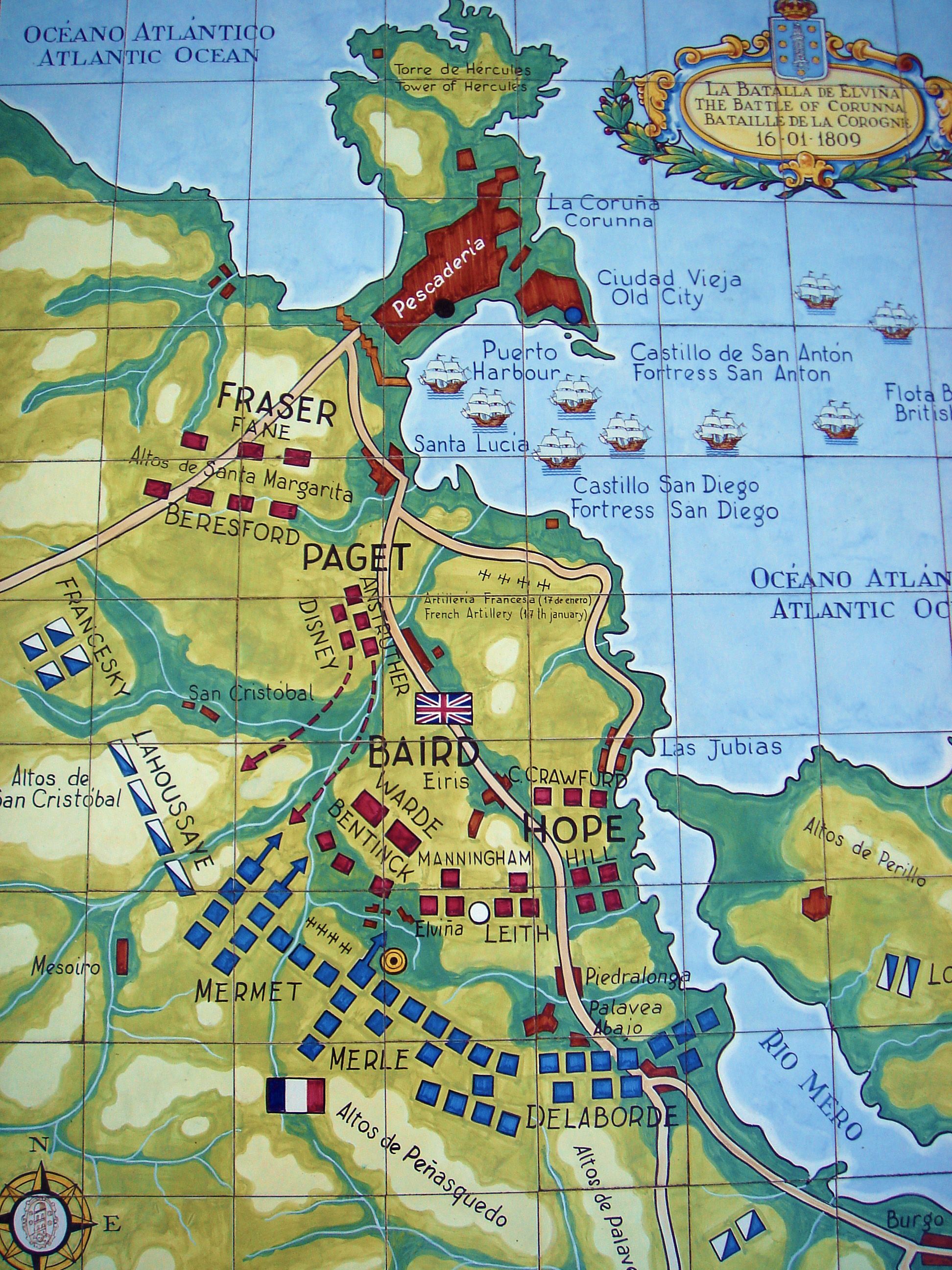
English: Map of the battle. Map of the Battle of Corunna in the Napoleonic wars. Red squares represent British infantry, blue squares represent French infantry and blue and white squares represent French cavalry. The white dot represents the place in which Moore was fatally wounded, the black dot the place in which he died and the blue dot the place in which he is buried now. The yellow dot represents the place in which this tiled map is located.
Français : Carte de la bataille. Carte de la bataille de la Corogne au cours de la guerre d'Espagne. Les rectangles rouges représentent l'infanterie anglaise, les rectangles bleus représentent l'infanterie française et les rectangles bleus et blancs la cavalerie française. Le point blanc situe l'endroit ou le général Moore est frappé mortellement par un boulet, le point noir, l'endroit où il expire et le point bleu l'endroit où il est enterré. Le point jaune représente l'emplacement de la carte.
Galego: Mapa da batalla. Mapa da Batalla de Elviña nas guerras napoleónicas. Os cadros vermellos representan a infantaría británica, os cadros azuis a infantaría francesa e os cuadros azuis e brancos a cabalaría francesa. O punto branco representa o local no que Moore foi ferido, o punto negro o local no que finalmente finou e o punto azul o local onde fica soterrado actualmente. O punto amarelo con círculos concéntricos representa o local onde se acha este mapa conmemorativo feito en azulexos. |
| Date | 3 May 2006 (according to Exif data) |
| Source | No machine-readable source provided. Own work assumed (based on copyright claims). |
| Author | No machine-readable author provided. E Mosqueira assumed (based on copyright claims). |
Licensing
I, the copyright holder of this work, hereby publish it under the following licenses:

|
Permission is granted to copy, distribute and/or modify this document under the terms of the GNU Free Documentation License, Version 1.2 or any later version published by the Free Software Foundation; with no Invariant Sections, no Front-Cover Texts, and no Back-Cover Texts. A copy of the license is included in the section entitled GNU Free Documentation License. |
| This file is licensed under the Creative Commons Attribution-Share Alike 3.0 Unported license. | ||
| ||
| This licensing tag was added to this file as part of the GFDL licensing update. |
This file is licensed under the Creative Commons Attribution-Share Alike 2.5 Generic license.
- You are free:
- to share – to copy, distribute and transmit the work
- to remix – to adapt the work
- Under the following conditions:
- attribution – You must give appropriate credit, provide a link to the license, and indicate if changes were made. You may do so in any reasonable manner, but not in any way that suggests the licensor endorses you or your use.
- share alike – If you remix, transform, or build upon the material, you must distribute your contributions under the same or compatible license as the original.
You may select the license of your choice.
File history
Click on a date/time to view the file as it appeared at that time.
| Date/Time | Thumbnail | Dimensions | User | Comment | |
|---|---|---|---|---|---|
| current | 22:09, 12 January 2012 | | 1,944 × 2,592 (1.9 MB) | MarcusBritish | Remove blue tint. |
| 18:46, 4 May 2006 |  | 1,944 × 2,592 (2.01 MB) | E Mosqueira | Mapa de la Batalla de Elviña en las guerras napoleonicas. Los cuadros rojos representan la infantería britanica, los cuadros azules la infantería frances y los cuadros azules y blancos la caballeria francesa. El punto blanco representa el lugar en el q |
File usage
The following pages on the English Wikipedia use this file (pages on other projects are not listed):
Global file usage
The following other wikis use this file:
- Usage on be-tarask.wikipedia.org
- Usage on be.wikipedia.org
- Usage on ca.wikipedia.org
- Usage on cs.wikipedia.org
- Usage on de.wikipedia.org
- Usage on es.wikipedia.org
- Usage on fr.wikipedia.org
- Usage on gl.wikipedia.org
- Usage on it.wikipedia.org
- Usage on ja.wikipedia.org
- Usage on lt.wikipedia.org
- Usage on nl.wikipedia.org
- Usage on nn.wikipedia.org
- Usage on pl.wikipedia.org
- Usage on pt.wikipedia.org
- Usage on ru.wikipedia.org
- Usage on sl.wikipedia.org
- Usage on ur.wikipedia.org
- Usage on zh.wikipedia.org