
File:Bassetlaw Parishes.svg

Size of this PNG preview of this SVG file: 513 × 561 pixels. Other resolutions: 219 × 240 pixels | 439 × 480 pixels | 702 × 768 pixels | 936 × 1,024 pixels | 1,873 × 2,048 pixels.
Original file (SVG file, nominally 513 × 561 pixels, file size: 78 KB)
| This is a file from the Wikimedia Commons. Information from its description page there is shown below. Commons is a freely licensed media file repository. You can help. |
Summary
| Description |
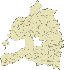
English: Map of Bassetlaw parishes |
| Date | |
| Source | Own work |
| Author | Mirrorme22 |
Licensing
| I, the copyright holder of this work, release this work into the public domain. This applies worldwide. In some countries this may not be legally possible; if so: I grant anyone the right to use this work for any purpose, without any conditions, unless such conditions are required by law. |
File history
Click on a date/time to view the file as it appeared at that time.
| Date/Time | Thumbnail | Dimensions | User | Comment | |
|---|---|---|---|---|---|
| current | 16:40, 14 January 2011 | | 513 × 561 (78 KB) | Mirrorme22 | Colour scheme changed, unparished areas now shown. |
| 17:45, 21 September 2010 |  | 513 × 561 (30 KB) | Mirrorme22 | {{Information |Description={{en|1=Map of Bassetlaw parishes}} |Source={{own}} |Author=Mirrorme22 |Date=2010-09-21 |Permission= |other_versions= }} Category:Maps |
File usage
The following pages on the English Wikipedia use this file (pages on other projects are not listed):
Global file usage
The following other wikis use this file: