
File:Barnard Castle station, with trains 1953 (geograph 5201685).jpg
Size of this preview: 800 × 391 pixels. Other resolutions: 320 × 157 pixels | 640 × 313 pixels | 1,024 × 501 pixels | 1,280 × 626 pixels | 2,322 × 1,136 pixels.
Original file (2,322 × 1,136 pixels, file size: 1.34 MB, MIME type: image/jpeg)
| This is a file from the Wikimedia Commons. Information from its description page there is shown below. Commons is a freely licensed media file repository. You can help. |
.jpg)
Summary
| Description |
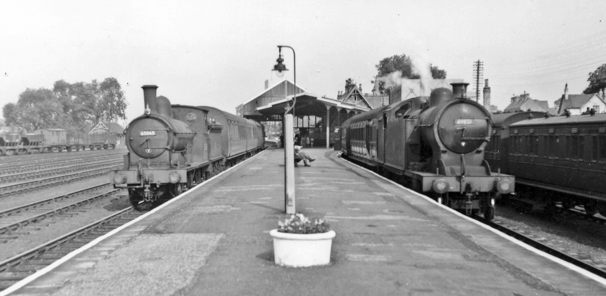
English: Barnard Castle station, with trains 1953. View east on the island platform, with two trains: on the left, Worsdell NER J21 0-6-0 No. 65068 (built 12/1890 as No. 300, 1946 LNER No. 5068, withdrawn 6/54) on a Darlington - Kirby Stephen - Penrith train; on the right is NER A8 4-6-2T No. 69851 (built 10/1913 as No. 2144, withdrawn 11/58) on a Sunderland - Middleton-in-Teesdale train. Barnard Castle station was closed 30/11/64 (passengers), 6/4/65 to goods, following closure of the Middleton line; the Darlington - Penrith line over Stainmore closed 20/1/62 and that from Bishop Auckland from 20/6/62. |
| Date | |
| Source | From geograph.org.uk |
| Author | Walter Dendy, deceased |
| Permission (Reusing this file) |
Creative Commons Attribution Share-alike license 2.0 |
| Attribution (required by the license) | Walter Dendy, deceased / Barnard Castle station, with trains 1953 / |
| Camera location | | View this and other nearby images on: OpenStreetMap |
|---|
.jpg¶ms=054.553527_N_-001.917560_E_globe:Earth_type:camera_heading:90.00_source:geograph&language=en)
| Object location | | View this and other nearby images on: OpenStreetMap |
|---|
.jpg¶ms=054.553570_N_-001.917500_E_globe:Earth_class:object_type:object_source:geograph-osgb36(NZ05431759)_region:GB-GBN_heading:90.00&language=en)
Licensing

|
This image was taken from the Geograph project collection. See this photograph's page on the Geograph website for the photographer's contact details. The copyright on this image is owned by Walter Dendy, deceased and is licensed for reuse under the Creative Commons Attribution-ShareAlike 2.0 license.
|
This file is licensed under the Creative Commons Attribution-Share Alike 2.0 Generic license.
Attribution: Walter Dendy, deceased
- You are free:
- to share – to copy, distribute and transmit the work
- to remix – to adapt the work
- Under the following conditions:
- attribution – You must give appropriate credit, provide a link to the license, and indicate if changes were made. You may do so in any reasonable manner, but not in any way that suggests the licensor endorses you or your use.
- share alike – If you remix, transform, or build upon the material, you must distribute your contributions under the same or compatible license as the original.
File history
Click on a date/time to view the file as it appeared at that time.
| Date/Time | Thumbnail | Dimensions | User | Comment | |
|---|---|---|---|---|---|
| current | 09:23, 30 July 2017 | | 2,322 × 1,136 (1.34 MB) | Das48 | Transferred from geograph.co.uk using [https://tools.wmflabs.org/geograph2commons/ geograph2commons] |
File usage
The following pages on the English Wikipedia use this file (pages on other projects are not listed):
Global file usage
The following other wikis use this file:
- Usage on www.wikidata.org
.jpg)