
File:Ballast Point Map 1851.jpg
No higher resolution available.
Ballast_Point_Map_1851.jpg (334 × 363 pixels, file size: 47 KB, MIME type: image/jpeg)
| This is a file from the Wikimedia Commons. Information from its description page there is shown below. Commons is a freely licensed media file repository. You can help. |
Summary
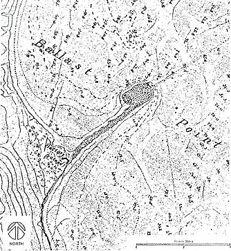
| Description | Map of Ballast Point and Fort Guijarros, near present-day San Diego, California, 1851. Caption at source reads, "San Diego Bay, California. “Battery (ruined)”; Enlarged detail of the tracing on the plan table sheet of the San Diego Bay, California. Survey by A.M. Harrison. Source: U.S. Coast Survey, 1851." |
| Date | |
| Source | [1] |
| Author | Uploaded by Johntex |
![[1]](http://soap.sdsu.edu/Volume1/FtGuijarrosWalls/images/fig7_8.jpg)
Licensing
This media file is in the public domain in the United States. This applies to U.S. works where the copyright has expired, often because its first publication occurred prior to January 1, 1929, and if not then due to lack of notice or renewal. See this page for further explanation.
|
 | |
 |
This image might not be in the public domain outside of the United States; this especially applies in the countries and areas that do not apply the rule of the shorter term for US works, such as Canada, Mainland China (not Hong Kong or Macao), Germany, Mexico, and Switzerland. The creator and year of publication are essential information and must be provided. See Wikipedia:Public domain and Wikipedia:Copyrights for more details.
|
File history
Click on a date/time to view the file as it appeared at that time.
| Date/Time | Thumbnail | Dimensions | User | Comment | |
|---|---|---|---|---|---|
| current | 23:38, 2 March 2008 | | 334 × 363 (47 KB) | Johntex~commonswiki | {{Information |Description=Map of Ballast Point and Fort Guijarros, near present-day San Diego, California, 1851. Caption at source reads, "San Diego Bay, California. “Battery (ruined)”; Enlarged detail of the tracing on the plan table sheet of t |
File usage
The following pages on the English Wikipedia use this file (pages on other projects are not listed):