
File:Balkans 6th century.svg

Size of this PNG preview of this SVG file: 800 × 431 pixels. Other resolutions: 320 × 173 pixels | 640 × 345 pixels | 1,024 × 552 pixels | 1,280 × 690 pixels | 2,560 × 1,381 pixels | 1,400 × 755 pixels.
Original file (SVG file, nominally 1,400 × 755 pixels, file size: 1.83 MB)
| This is a file from the Wikimedia Commons. Information from its description page there is shown below. Commons is a freely licensed media file repository. You can help. |
Summary
| Description |
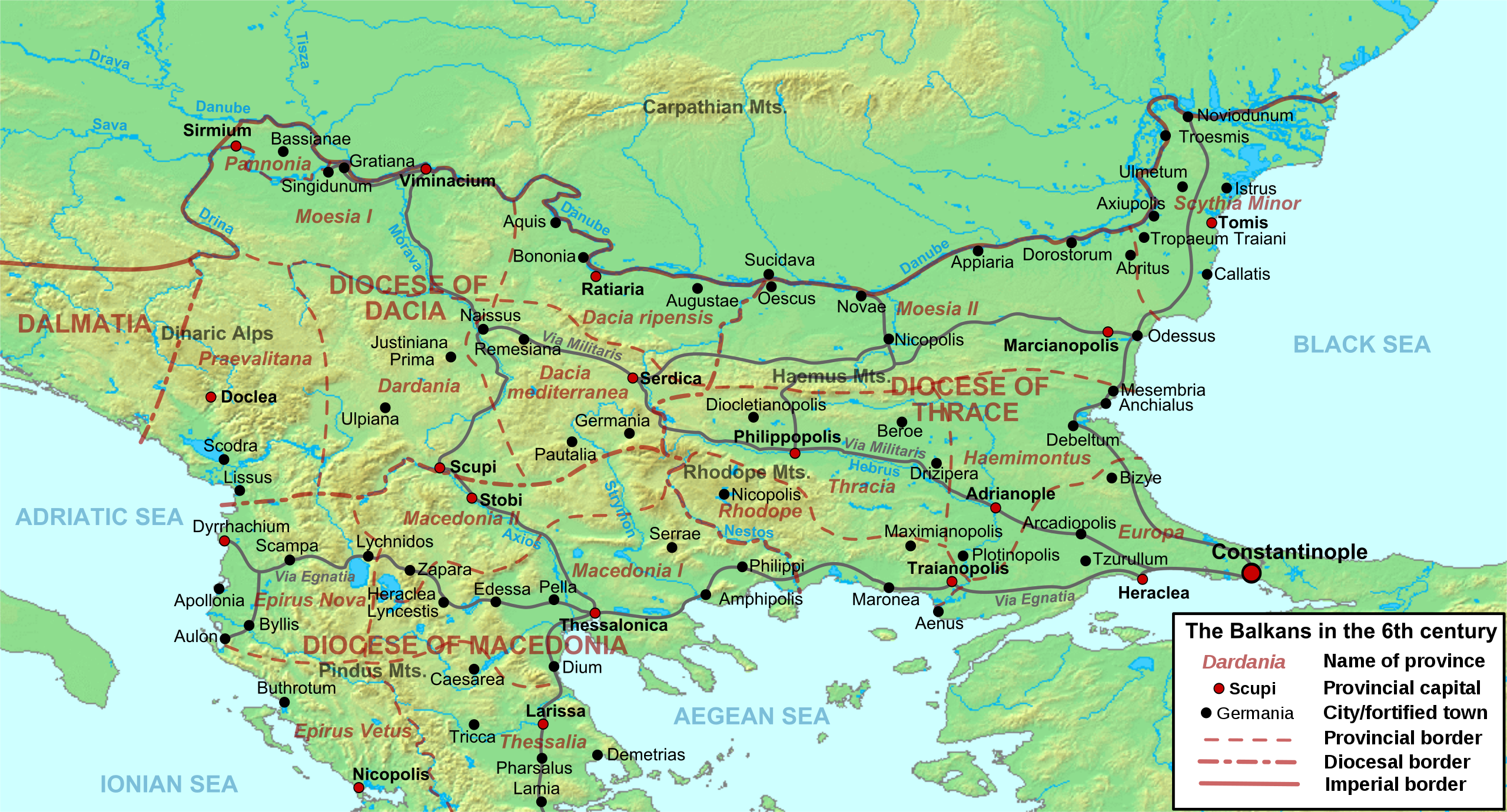
Deutsch: Die nördliche Balkanhalbinsel in der Spätantike (6. Jahrhundert), mit den spätrömischen Provinzen, Hauptsiedlungen und Straẞen.
English: Map of the northern Balkans in the 6th century AD, with the Roman provinces, major settlements and roads.
Français : Carte des Balkans septentrionaux au VIe siècle, à la veille de l'arrivée des Slaves, avec les provinces romains, les villes et les routes les plus importantes. |
| Date | |
| Source |
Own work based on:
|
| Author | Cplakidas |
| Other versions |
[]
|


Licensing
I, the copyright holder of this work, hereby publish it under the following licenses:
This file is licensed under the Creative Commons Attribution-Share Alike 3.0 Unported license.
- You are free:
- to share – to copy, distribute and transmit the work
- to remix – to adapt the work
- Under the following conditions:
- attribution – You must give appropriate credit, provide a link to the license, and indicate if changes were made. You may do so in any reasonable manner, but not in any way that suggests the licensor endorses you or your use.
- share alike – If you remix, transform, or build upon the material, you must distribute your contributions under the same or compatible license as the original.

|
Permission is granted to copy, distribute and/or modify this document under the terms of the GNU Free Documentation License, Version 1.2 or any later version published by the Free Software Foundation; with no Invariant Sections, no Front-Cover Texts, and no Back-Cover Texts. A copy of the license is included in the section entitled GNU Free Documentation License. |
You may select the license of your choice.
File history
Click on a date/time to view the file as it appeared at that time.
| Date/Time | Thumbnail | Dimensions | User | Comment | |
|---|---|---|---|---|---|
| current | 09:52, 11 May 2012 | | 1,400 × 755 (1.83 MB) | Cplakidas | corrected locations of Thracia and Haemimontus, minor tweaks elsewhere |
| 20:27, 7 January 2012 |  | 1,400 × 755 (1.91 MB) | Cplakidas | Left-over names to paths | |
| 20:29, 1 March 2010 |  | 1,400 × 755 (2.1 MB) | Cplakidas | names to paths | |
| 20:20, 1 March 2010 |  | 1,400 × 755 (1.08 MB) | Cplakidas | {{Information |Description={{en|1=Map of the northern Balkans in the 6th century AD. Geophysical map taken from from [http://www2.demis.nl/mapserver/mapper.asp DEMIS Mapserver], which are public domain, other wise self-made. Sources: [http://soltdm.com/so |
File usage
The following pages on the English Wikipedia use this file (pages on other projects are not listed):
- 593
- Albania under the Byzantine Empire
- Avar–Byzantine wars
- Battles of Viminacium
- Comentiolus
- Dacia Aureliana
- Dacia Mediterranea
- Dacia Ripensis
- Danubian Limes
- Dardani
- Dardania (Roman province)
- Diocese of Dacia
- Europa (Roman province)
- History of Albania
- Justin (consul 540)
- List of ancient cities in Thrace and Dacia
- Maurice's Balkan campaigns
- Maurice (emperor)
- Moesia
- Pannonia (Byzantine province)
- Peter (curopalates)
- Praevalitana
- Priscus (magister militum)
- Ratiaria
- Serbia in the Middle Ages
- Siege of Sirmium
- Siege of Thessalonica (617)
- Via Militaris
- User:Falcaorib
Global file usage
The following other wikis use this file:
- Usage on ar.wikipedia.org
- Usage on azb.wikipedia.org
- Usage on be.wikipedia.org
- Usage on bg.wikipedia.org
- Usage on bs.wikipedia.org
- Usage on cs.wikipedia.org
- Usage on de.wikipedia.org
- Usage on el.wikipedia.org
- Usage on es.wikipedia.org
- Usage on et.wikipedia.org
- Usage on fa.wikipedia.org
View more global usage of this file.