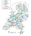
File:Baanvaksnelheden.png

Size of this preview: 496 × 600 pixels. Other resolutions: 198 × 240 pixels | 397 × 480 pixels | 635 × 768 pixels | 1,187 × 1,435 pixels.
Original file (1,187 × 1,435 pixels, file size: 351 KB, MIME type: image/png)
File history
Click on a date/time to view the file as it appeared at that time.
| Date/Time | Thumbnail | Dimensions | User | Comment | |
|---|---|---|---|---|---|
| current | 10:44, 17 October 2012 |  | 1,187 × 1,435 (351 KB) | Classical geographer | Hanzelijn now completed (even though still without traffic). Changed colours slightly, notably making the HSL-Zuid red, and the slowest lines black. Amsterdam-Utrecht still 160 km/h; upgrade to 200 km/h now in doubt, as explained at http://www.sp.nl/ve... |
| 21:48, 5 August 2010 |  | 1,265 × 1,529 (352 KB) | AgentX~commonswiki | Reverted to version as of 20:40, 27 July 2009 | |
| 21:46, 5 August 2010 |  | 1,265 × 1,529 (317 KB) | AgentX~commonswiki | ||
| 20:40, 27 July 2009 |  | 1,265 × 1,529 (352 KB) | Classical geographer | Newly added links are non-electrified. Also changed background from blurry image to fresh new image. (Actually, File:Blank map of the Netherlands.svg.) I also discovered the line from Heerlen towards Aken is non-electrified, judging from [[:File:Sta | |
| 19:45, 27 July 2009 |  | 1,743 × 1,986 (899 KB) | Classical geographer | Several small fixed: * moved some stations to better locations * removed some small stations (without labels) that are not end-points or really important junctions; I'm considering whether to label them and, importantly, * added Betuweroute * added inte | |
| 08:20, 11 July 2009 |  | 1,394 × 1,588 (639 KB) | Classical geographer | Moved Enkhuizen onto land. Also adjusted Lelystad and (invisible) Meppel somehwat. | |
| 17:24, 8 April 2009 |  | 1,573 × 1,942 (1.08 MB) | T Houdijk | More changes; Zutphen-Hengelo is non-electrified | |
| 20:36, 20 February 2009 |  | 1,573 × 1,942 (1.19 MB) | Classical geographer | Another change: Leeuwarden-Groningen 140 km/h all the way, instead of only the double-track section. Also added scale and north arrow. | |
| 15:13, 15 March 2008 |  | 1,743 × 1,986 (352 KB) | T Houdijk | Fixed a few errors in this map. | |
| 16:15, 3 December 2007 |  | 1,743 × 1,986 (528 KB) | Classical geographer |
File usage
The following pages on the English Wikipedia use this file (pages on other projects are not listed):
Global file usage
The following other wikis use this file:
- Usage on de.wikipedia.org
- Usage on es.wikipedia.org
- Usage on fr.wikipedia.org
- Usage on hu.wikipedia.org
- Usage on ja.wikipedia.org
- Usage on nl.wikipedia.org
- Usage on sv.wikipedia.org


