
File:BART-WS-extension-map.png
No higher resolution available.
BART-WS-extension-map.png (521 × 537 pixels, file size: 85 KB, MIME type: image/png)
| This is a file from the Wikimedia Commons. Information from its description page there is shown below. Commons is a freely licensed media file repository. You can help. |
Summary

|
File:BART WSX overlay.svg is a vector version of this file. It should be used in place of this PNG file when not inferior.
File:BART-WS-extension-map.png → File:BART WSX overlay.svg
For more information, see Help:SVG. |
 |
| Description |
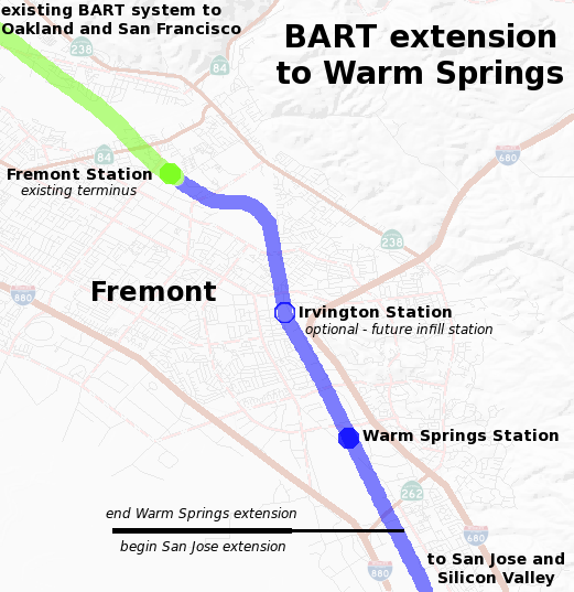
English: Map of the planned Bay Area Rapid Transit extension to Warm Springs. The background map of Fremont was generated by the USGS National Map. The route and plans are based on data from BART including the Warm Springs project alignment description. |
| Date | |
| Source | Own work |
| Author | Ikluft |
Licensing
I, the copyright holder of this work, hereby publish it under the following license:
This file is licensed under the Creative Commons Attribution-Share Alike 3.0 Unported license.
- You are free:
- to share – to copy, distribute and transmit the work
- to remix – to adapt the work
- Under the following conditions:
- attribution – You must give appropriate credit, provide a link to the license, and indicate if changes were made. You may do so in any reasonable manner, but not in any way that suggests the licensor endorses you or your use.
- share alike – If you remix, transform, or build upon the material, you must distribute your contributions under the same or compatible license as the original.
File history
Click on a date/time to view the file as it appeared at that time.
| Date/Time | Thumbnail | Dimensions | User | Comment | |
|---|---|---|---|---|---|
| current | 21:42, 2 January 2017 | | 521 × 537 (85 KB) | Jeanjung212 | Lossless Compressed/optimized png decreasing file size by 48050 bytes |
| 00:52, 14 December 2008 |  | 521 × 537 (132 KB) | Ikluft | major cleanup - add mid-background layer with highways and highway shields | |
| 11:19, 7 December 2008 |  | 521 × 537 (180 KB) | Ikluft | {{Information |Description={{en|1=Map of the planned Bay Area Rapid Transit extension to Warm Springs. The background map of Fremont was generated by the [http://www.nationalmap.gov/ USGS National Map]. The route and plans are |
File usage
The following pages on the English Wikipedia use this file (pages on other projects are not listed):
Global file usage
The following other wikis use this file:
- Usage on nl.wikipedia.org