
File:Aylesbury Station geograph-3933405-by-Ben-Brooksbank.jpg
Size of this preview: 800 × 526 pixels. Other resolutions: 320 × 210 pixels | 640 × 421 pixels | 1,024 × 673 pixels | 1,280 × 842 pixels | 2,340 × 1,539 pixels.
Original file (2,340 × 1,539 pixels, file size: 3.39 MB, MIME type: image/jpeg)
| This is a file from the Wikimedia Commons. Information from its description page there is shown below. Commons is a freely licensed media file repository. You can help. |
Summary
| Description |
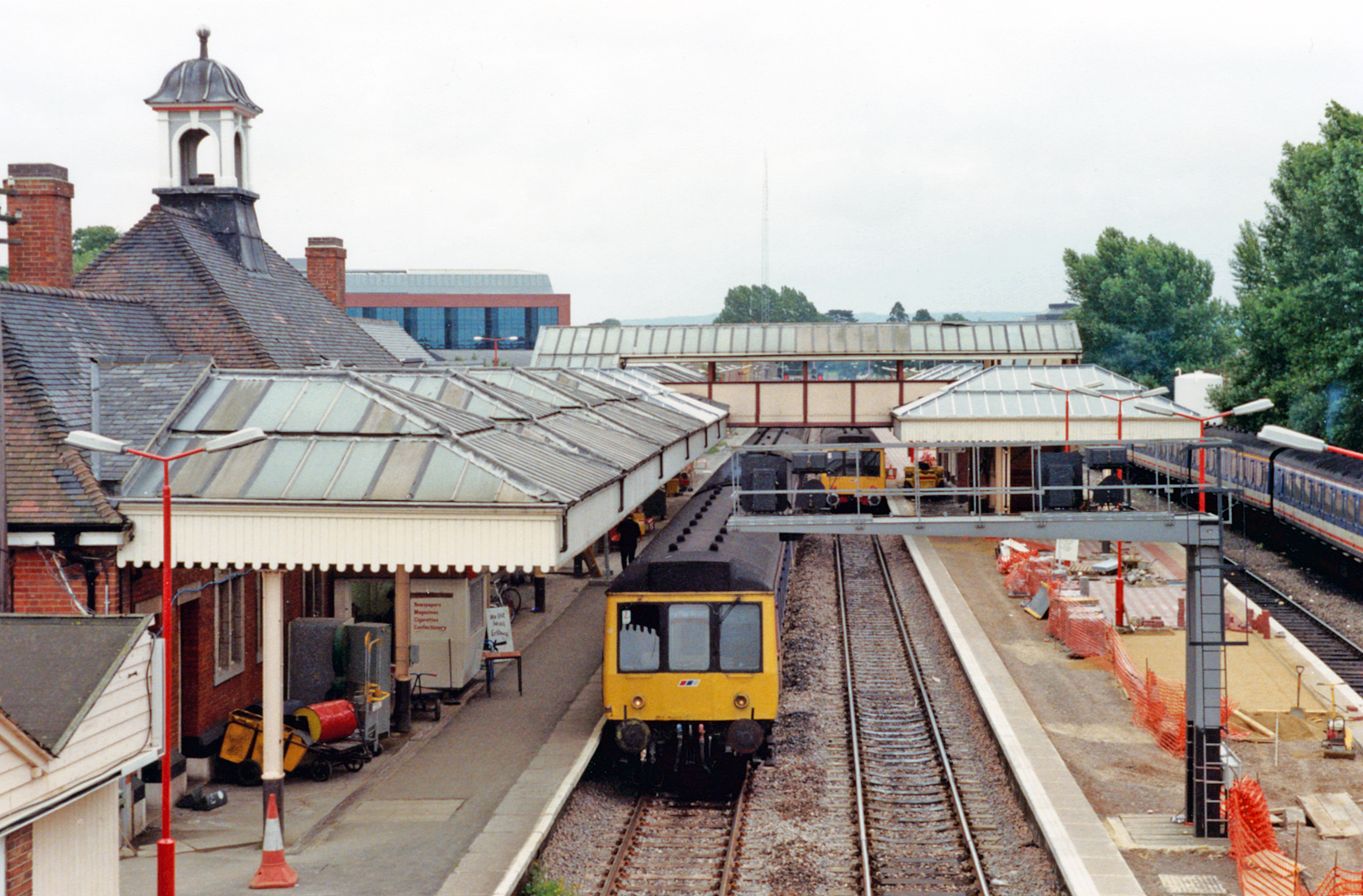
English: Aylesbury Station, 1991. View SE, towards Amersham and London, also Princes Risborough: ex-Metropolitan & GC Joint main line from London (Marylebone, formerly also Baker Street), to Leicester, Nottingham and Sheffield by the ex-GCR 'London Extension (closed 5/9/66). The Metropolitan (LPTB from 1933) from Baker Street ran through to Verney Junction until 1936, but from 6/61 was cut back to Amersham. The ex-GW & GC Joint branch from Princes Risborough also remains. Here in 1991 this former Aylesbury ('Joint', later 'Town') station is being thoroughly refurbished: subsequently (12/08) trains will run on to the new Aylesbury Vale Parkway station on the residual line to Quainton Road. 'First Generation' DMUs dominate the services in 1991. |
| Date | |
| Source | From geograph.org.uk |
| Author | Ben Brooksbank |
| Permission (Reusing this file) |
Creative Commons Attribution Share-alike license 2.0 |
| Attribution (required by the license) | Ben Brooksbank / Aylesbury Station, 1991 / |
| Camera location | | View this and other nearby images on: OpenStreetMap |
|---|
Licensing

|
This image was taken from the Geograph project collection. See this photograph's page on the Geograph website for the photographer's contact details. The copyright on this image is owned by Ben Brooksbank and is licensed for reuse under the Creative Commons Attribution-ShareAlike 2.0 license.
|
This file is licensed under the Creative Commons Attribution-Share Alike 2.0 Generic license.
Attribution: Ben Brooksbank
- You are free:
- to share – to copy, distribute and transmit the work
- to remix – to adapt the work
- Under the following conditions:
- attribution – You must give appropriate credit, provide a link to the license, and indicate if changes were made. You may do so in any reasonable manner, but not in any way that suggests the licensor endorses you or your use.
- share alike – If you remix, transform, or build upon the material, you must distribute your contributions under the same or compatible license as the original.
File history
Click on a date/time to view the file as it appeared at that time.
| Date/Time | Thumbnail | Dimensions | User | Comment | |
|---|---|---|---|---|---|
| current | 08:11, 17 May 2014 | | 2,340 × 1,539 (3.39 MB) | Chevin | == {{int:filedesc}} == {{Information |Description={{en|1='''Aylesbury Station, 1991.'''<br/> View SE, towards Amersham and London, also Princes Risborough: ex-Metropolitan & GC Joint main line from London (Marylebone, formerly also Baker Street), to Le... |
File usage
The following pages on the English Wikipedia use this file (pages on other projects are not listed):