
File:Australia Victoria East Gippsland Shire location map.svg

Size of this PNG preview of this SVG file: 533 × 353 pixels. Other resolutions: 320 × 212 pixels | 640 × 424 pixels | 1,024 × 678 pixels | 1,280 × 848 pixels | 2,560 × 1,695 pixels.
Original file (SVG file, nominally 533 × 353 pixels, file size: 893 KB)
| This is a file from the Wikimedia Commons. Information from its description page there is shown below. Commons is a freely licensed media file repository. You can help. |
| Description |
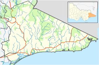
English: Blank map of w:East Gippsland Shire, Victoria, Australia, with the following information shown:
Geographic limits:
|
||
| Source | Own work + VicMap Lite | ||
| Author | Cassowary |

File history
Click on a date/time to view the file as it appeared at that time.
| Date/Time | Thumbnail | Dimensions | User | Comment | |
|---|---|---|---|---|---|
| current | 12:56, 17 February 2011 | | 533 × 353 (893 KB) | Cassowary | {{Information |Description ={{en|1=Blank map of w:East Gippsland Shire, Victoria, Australia, with the following information shown: * LGA boundaries * Coastline, lakes and rivers * Roads and railways * Urban areas * Parks Geographic limits: * North |
File usage
The following pages on the English Wikipedia use this file (pages on other projects are not listed):
- Anglers Rest, Victoria
- Bairnsdale
- Bemm River, Victoria
- Benambra, Victoria
- Bendoc, Victoria
- Bonang Road
- Bruthen, Victoria
- Buchan, Victoria
- Cann River, Victoria
- Cape Conran
- Cassilis, Victoria
- Clifton Creek, Victoria
- Delegate River, Victoria
- Deptford, Victoria
- Double Bridges, Victoria
- Eagle Point, Victoria
- East Gippsland Football League
- Eastwood, Victoria
- Ensay, Victoria
- Fernbank, Victoria
- Gabo Island
- Gelantipy
- Genoa, Victoria
- Goon Nure, Victoria
- Goongerah, Victoria
- Johnsonville, Victoria
- Lake Tyers Mission
- Lakes Entrance, Victoria
- Lindenow, Victoria
- Lucknow, Victoria
- Mallacoota, Victoria
- Marlo, Victoria
- Metung
- Nelse, Victoria
- Newmerella, Victoria
- Nicholson, Victoria
- Nowa Nowa, Victoria
- Omeo
- Omeo & District Football League
- Orbost
- Orbost railway station
- Paynesville, Victoria
- Raymond Island
- Rotamah Island
- Shire of East Gippsland
- Suggan Buggan, Victoria
- Swan Reach, Victoria
- Swifts Creek
- Tambo Crossing, Victoria
- The Skerries (Victoria)
- Tongio, Victoria
- Tullaberga Island
- W Tree, Victoria
- Wingan River, Victoria
- Wy Yung, Victoria
- User:ThylacineHunter/LGA
- User:Viatori/sandbox
- Template:Towns in East Gippsland Shire
- Module:Location map/data/Australia Victoria Shire of East Gippsland
- Module:Location map/data/Australia Victoria Shire of East Gippsland/doc
Global file usage
The following other wikis use this file:
- Usage on ar.wikipedia.org
- Usage on ceb.wikipedia.org
- Usage on fa.wikipedia.org
- Usage on kn.wikipedia.org
- Usage on pnb.wikipedia.org
- Usage on sd.wikipedia.org
- Usage on simple.wikipedia.org
- Usage on si.wikipedia.org
- Usage on tr.wikipedia.org
- Usage on ur.wikipedia.org
- Usage on uz.wikipedia.org
- Usage on war.wikipedia.org