
File:Atlantico-municipios.svg

Size of this PNG preview of this SVG file: 417 × 599 pixels. Other resolutions: 167 × 240 pixels | 334 × 480 pixels | 535 × 768 pixels | 713 × 1,024 pixels | 1,426 × 2,048 pixels | 532 × 764 pixels.
Original file (SVG file, nominally 532 × 764 pixels, file size: 105 KB)
| This is a file from the Wikimedia Commons. Information from its description page there is shown below. Commons is a freely licensed media file repository. You can help. |
Summary
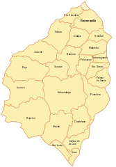
| Description | Mapa en formato svg del departamento del Atlántico, en Colombia. |
| Date | 24 July 2007 (original upload date) |
| Source | No machine-readable source provided. Own work assumed (based on copyright claims). |
| Author | No machine-readable author provided. Canislupusarctos assumed (based on copyright claims). |
Licensing
| This work has been released into the public domain by its author, I, Canislupusarctos. This applies worldwide. In some countries this may not be legally possible; if so: I, Canislupusarctos grants anyone the right to use this work for any purpose, without any conditions, unless such conditions are required by law. |
File history
Click on a date/time to view the file as it appeared at that time.
| Date/Time | Thumbnail | Dimensions | User | Comment | |
|---|---|---|---|---|---|
| current | 23:13, 24 July 2007 | | 532 × 764 (105 KB) | Canislupusarctos | Mapa en formato svg del departamento del Atlántico, en Colombia. |
| 23:08, 24 July 2007 |  | 532 × 764 (92 KB) | Canislupusarctos | ||
| 18:38, 24 July 2007 |  | 532 × 764 (91 KB) | Canislupusarctos | ||
| 18:34, 24 July 2007 |  | 532 × 764 (89 KB) | Canislupusarctos | Mapa en formato svg del departamento del Atlántico, en Colombia. |
File usage
No pages on the English Wikipedia use this file (pages on other projects are not listed).
Global file usage
The following other wikis use this file:
- Usage on az.wikipedia.org
- Usage on es.wikipedia.org
- Usage on hr.wikipedia.org
- Usage on ilo.wikipedia.org
- Usage on ja.wikipedia.org
- Usage on ka.wikipedia.org
- Usage on ms.wikipedia.org
- Usage on ru.wikipedia.org
- Usage on sco.wikipedia.org
- Usage on vi.wikipedia.org
- Usage on zh.wikipedia.org