
File:Atenis Sioni view.jpg

Size of this preview: 800 × 533 pixels. Other resolutions: 320 × 213 pixels | 640 × 427 pixels | 1,024 × 683 pixels | 1,280 × 853 pixels | 2,560 × 1,707 pixels | 4,272 × 2,848 pixels.
Original file (4,272 × 2,848 pixels, file size: 8.15 MB, MIME type: image/jpeg)
| This is a file from the Wikimedia Commons. Information from its description page there is shown below. Commons is a freely licensed media file repository. You can help. |
Summary
| Description |
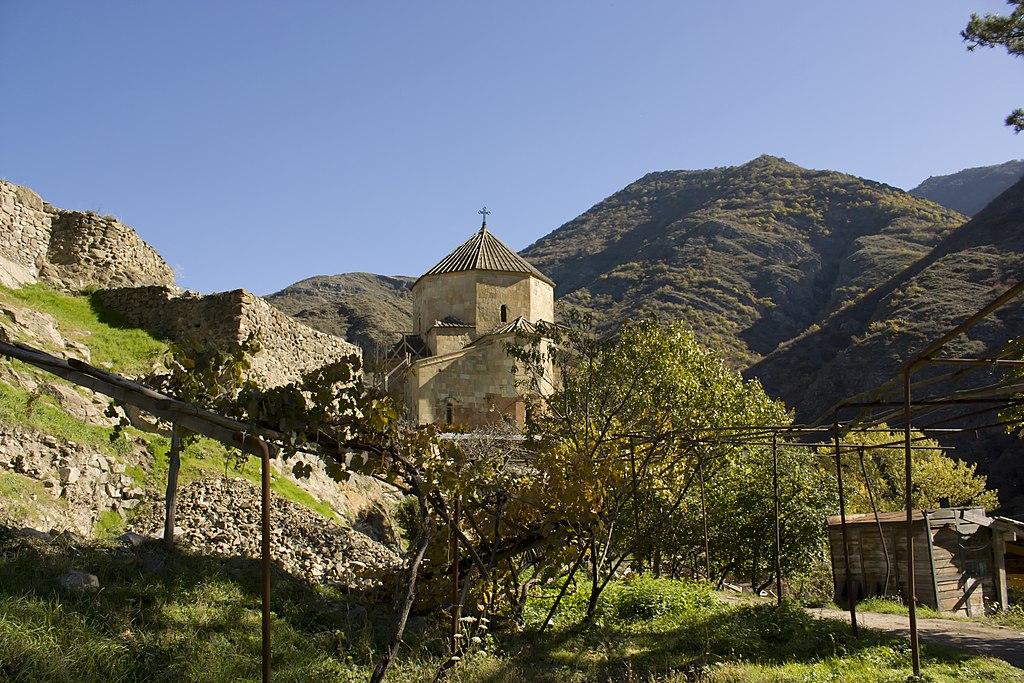
Deutsch: Georgische Kirche Ateni Sioni aus dem 7. Jahrhundert, südlich von Gori.
English: The Ateni Sioni Church (Georgian: ატენის სიონი) is an early 7th-century Georgian Orthodox church some 10 km (6 miles) south of the city of Gori, Georgia. It stands in a setting of the Tana River valley known not only for its historical monuments but also for its picturesque landscapes and wine. The name "Sioni" derives from Mount Zion at Jerusalem.
Suomi: Atenis Sionin kirkko on 600-luvun alussa rakennettu georgialaisortodoksinen kirkko noin kymmenen kilometriä etelään Gorin kaupungista Georgiassa. Kirkko sijaitsee Tana-joen laaksossa, joka tunnetaan historiallisten monumenttiensa lisäksi maisemistaan ja viinistään. Nimi "Sioni" juontuu Jerusalemin Siionin vuorelta. (→Atenis Sioni)
Français : L’église Sioni d’Ateni ou Atenis Sioni (en géorgien: ატენის სიონი) au sud de la ville de Gori. Elle se trouve dans la vallée du Tana, connue pour ses monuments historiques, ses paysages pittoresques et son vin régional. Le nom « Sioni » vient du mont Sion à Jérusalem. (→Église Sioni d'Ateni)
עברית: כנסיית אָטֶנִי סִיוֹנִי (גאורגית: ატენის სიონი) היא כנסייה מתחילת המאה השביעית של הכנסייה הגאורגית. היא ממוקמת כ-10 ק"מ (6 מייל) דרומית לעיר גורי שבגאורגיה, על רקע נופיו של עמק נהר הטָאנַה (ტანა), הידועה לא רק בשל המונומנטים ההיסטוריים שלה אלה גם בשל נופיה הציוריים והיין. הכנסייה נקראת "סיוני" על שם הר ציון שבירושלים.
Հայերեն: Աթենի Սիոնը վրացական Սիոնի վանքն է, Աթենի գյուղում (10 կմ դեպի հարավ Գորիից): (→Աթենի Սիոն)
ქართული: ატენის სიონი — VII საუკუნის I ნახევრის ქართული ხუროთმოძღვრების ძეგლი დგას, გორიდან 12 კმ-ზე, ატენის ხეობაში, მდ. ტანას მარცხენა ნაპირას, ფრიალო კლდის კიდეზე, საყრდენი კედლით გამაგრებულ ბაქანზე. (→ატენის სიონი)
Русский: Атенский Сион — грузинский монастырь Сиони в селе Атени (10 км к югу от Гори), построенный в I-й половине VII века зодчим Тодосом по образцу Джвари (тетраконх). Уцелели в нем росписи 1080 года, а также видны следы пожара от нашествия шаха Аббаса I (который разжег в храме костер). В данный момент храм действующий, хотя по лесам можно судить о реставрационных работах которые ведутся как снаружи, так и внутри храма. Реставрация должна завершиться в 2010 году. (→Атенский Сион) |
| Date | 5 November 2010, 12:41:51 |
| Source | originally posted to Flickr as Atenis Sioni |
| Author | George Mel |
| Object location | | View this and other nearby images on: OpenStreetMap |
|---|
This image has been assessed using the Quality image guidelines and is considered a Quality image.
|
Licensing
This file is licensed under the Creative Commons Attribution-Share Alike 2.0 Generic license.
- You are free:
- to share – to copy, distribute and transmit the work
- to remix – to adapt the work
- Under the following conditions:
- attribution – You must give appropriate credit, provide a link to the license, and indicate if changes were made. You may do so in any reasonable manner, but not in any way that suggests the licensor endorses you or your use.
- share alike – If you remix, transform, or build upon the material, you must distribute your contributions under the same or compatible license as the original.
| This image, which was originally posted to Flickr, was uploaded to Commons using Flickr upload bot on 8 November 2010, 17:16 by Gaeser. On that date, it was confirmed to be licensed under the terms of the license indicated. |
File history
Click on a date/time to view the file as it appeared at that time.
| Date/Time | Thumbnail | Dimensions | User | Comment | |
|---|---|---|---|---|---|
| current | 07:53, 10 November 2010 | | 4,272 × 2,848 (8.15 MB) | DerFuchs | M |
| 17:20, 8 November 2010 |  | 4,272 × 2,848 (9.71 MB) | DerFuchs | Fullsize | |
| 17:16, 8 November 2010 |  | 1,024 × 683 (527 KB) | Flickr upload bot | Uploaded from http://flickr.com/photo/42573295@N02/5158140965 using Flickr upload bot |
File usage
The following pages on the English Wikipedia use this file (pages on other projects are not listed):
Global file usage
The following other wikis use this file:
- Usage on ba.wikipedia.org
- Usage on ceb.wikipedia.org
- Usage on de.wikivoyage.org
- Usage on es.wikipedia.org
- Usage on fa.wikipedia.org
- Usage on fi.wikipedia.org
- Usage on fr.wikipedia.org
- Usage on he.wikipedia.org
- Usage on hy.wikipedia.org
- Usage on ka.wikipedia.org
- Usage on pt.wikipedia.org
- Usage on ru.wikipedia.org
- Usage on tr.wikipedia.org
- Usage on uk.wikipedia.org
- Usage on www.wikidata.org