
File:Artsakh administrative map 2021.svg

Size of this PNG preview of this SVG file: 522 × 600 pixels. Other resolutions: 209 × 240 pixels | 418 × 480 pixels | 669 × 768 pixels | 892 × 1,024 pixels | 1,783 × 2,048 pixels | 788 × 905 pixels.
Original file (SVG file, nominally 788 × 905 pixels, file size: 327 KB)
| This is a file from the Wikimedia Commons. Information from its description page there is shown below. Commons is a freely licensed media file repository. You can help. |
Summary
| Description |
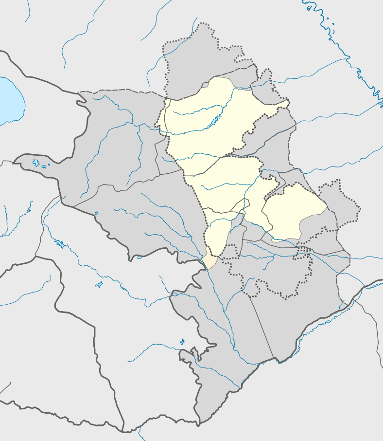
English: Administrative map of the breakaway Republic of Artsakh (2021).
Claimed and controlled by the Republic of Artsakh and Russian peacekeepers.
Lachin corridor, controlled by Russian peacekeepers.
Claimed by the Republic of Artsakh, but controlled by Azerbaijan. |
| Date | |
| Source | Own work |
| Author | AntonSamuel |
Licensing
I, the copyright holder of this work, hereby publish it under the following license:
This file is licensed under the Creative Commons Attribution-Share Alike 4.0 International license.
- You are free:
- to share – to copy, distribute and transmit the work
- to remix – to adapt the work
- Under the following conditions:
- attribution – You must give appropriate credit, provide a link to the license, and indicate if changes were made. You may do so in any reasonable manner, but not in any way that suggests the licensor endorses you or your use.
- share alike – If you remix, transform, or build upon the material, you must distribute your contributions under the same or compatible license as the original.
File history
Click on a date/time to view the file as it appeared at that time.
| Date/Time | Thumbnail | Dimensions | User | Comment | |
|---|---|---|---|---|---|
| current | 16:36, 26 August 2022 | | 788 × 905 (327 KB) | AntonSamuel | Fixes |
| 16:34, 26 August 2022 |  | 788 × 905 (327 KB) | AntonSamuel | Fixes | |
| 15:40, 26 August 2022 |  | 788 × 905 (327 KB) | AntonSamuel | Update | |
| 19:13, 18 May 2022 |  | 788 × 905 (328 KB) | AntonSamuel | - | |
| 19:08, 18 May 2022 |  | 788 × 905 (328 KB) | AntonSamuel | - | |
| 19:30, 6 January 2022 |  | 788 × 905 (328 KB) | AntonSamuel | - | |
| 19:28, 6 January 2022 |  | 788 × 905 (328 KB) | AntonSamuel | - | |
| 19:17, 6 January 2022 |  | 788 × 905 (327 KB) | AntonSamuel | Fixes | |
| 21:53, 15 November 2021 |  | 788 × 905 (327 KB) | Golden | fixing control around Mkhitarkend (line runs right near the village, not kms ahead of it) | |
| 20:59, 13 November 2021 |  | 788 × 905 (327 KB) | Golden | various control changes (Azeri control around Shusha isn't that tight, they control a hill few kms north of Shusha and control until the river in the west; one peak in Murovdag mountain was recaptured during the war; frontline is much closer to Martuni/Khojavend than previously shown) |
File usage
The following pages on the English Wikipedia use this file (pages on other projects are not listed):
- 2018 Artsakh Football League
- 2019 Artsakh Football League
- 2019 CONIFA European Football Cup
- 2021 Artsakh Football League
- Artsakh Football League
- List of cities and towns in Artsakh
- Monastery of Tsar
- Stepanakert in the Republic of Artsakh
- Tsakuri
- Tugh (village)
- Talk:Stepanakert/Archive 2
- Talk:Taghavard
- User:AntonSamuel/sandbox
- User:AntonSamuel/sandbox/a
- User:AntonSamuel/sandbox/b
- User:AntonSamuel/sandbox/c
- User:AntonSamuel/sandbox/d
- User:AntonSamuel/sandbox/e
- Module:Location map/data/Republic of Artsakh
- Module:Location map/data/Republic of Artsakh/doc
Global file usage
The following other wikis use this file:
- Usage on an.wikipedia.org
- Usage on eu.wikipedia.org
- Usage on fa.wikipedia.org
- استان مارتونی
- لاچین (شهر)
- کلیسای قازانچتسوتس آمناپرگیچ مقدس
- صومعه گاندزاسار
- مارتاکرت
- مارتونی
- کلبجر
- استپاناکرت
- شوشی
- آسکران
- بانادزور
- چلدران
- فرودگاه استپاناکرت
- استان شاهومیان
- ابدال (مارتونی)
- ابدالانلی
- عبداللهاوشاگی
- ادیگوزالبگلی
- اگزیبیر، کلبجر
- علاءالدین، زنگلان
- الاقوراشاق
- الچالی
- علیآغالی
- اللهکلولار
- الیکند، کالپاجار
- خندزریستان
- الولار
- الپوت، لاچین
- التینچی
- آلوکند
- آرواکان
- الیبیلی وتوری
- علیبیلی، زنگیلان
- علیجان، لاچین
- الیکیکسالی
- الیرزالار
- امراس
- امیرالار
- ترکخویلو
- باقرساق (روستا)
- وانک، مارتاکرت
- وانک (هادروت)
- واغازین
- وجنلی
- ورین قلیچباغ
- ورین سیزنک
- تکقایاسی
View more global usage of this file.