
File:Arizona ref 2001.jpg

Size of this preview: 506 × 599 pixels. Other resolutions: 203 × 240 pixels | 405 × 480 pixels | 677 × 802 pixels.
Original file (677 × 802 pixels, file size: 283 KB, MIME type: image/jpeg)
| This is a file from the Wikimedia Commons. Information from its description page there is shown below. Commons is a freely licensed media file repository. You can help. |
| Description |
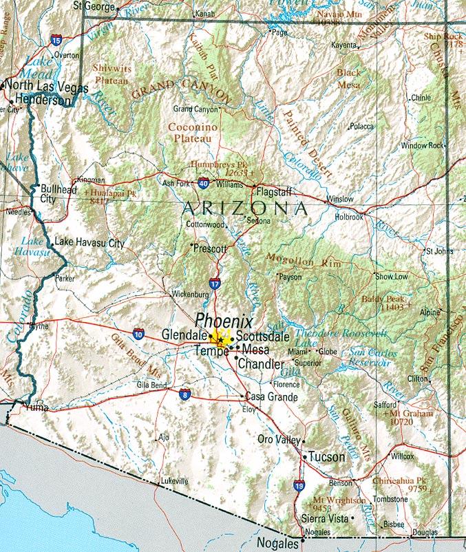
English: Map of Arizona. Shaded relief map with state boundaries, forest cover, place names, major highways. Portion of "The National Atlas of the United States of America. General Reference", compiled by U.S. Geological Survey 2001, printed 2002 |
|||
| Date | ||||
| Source | Courtesy of the University of Texas Libraries, The University of Texas at Austin | |||
| Author | U.S. Geological Survey 2001 | |||
| Permission (Reusing this file) |
|
File history
Click on a date/time to view the file as it appeared at that time.
| Date/Time | Thumbnail | Dimensions | User | Comment | |
|---|---|---|---|---|---|
| current | 16:10, 22 January 2006 | | 677 × 802 (283 KB) | Severino666~commonswiki | :''"Courtesy of the University of Texas Libraries, The The University of Texas at Austin.'' *'''Source:''' [http://en.wikipedia.org/wiki/Image:Texas_2002.jpg University of Texas Libraries] |
File usage
The following pages on the English Wikipedia use this file (pages on other projects are not listed):
Global file usage
The following other wikis use this file:
- Usage on de.wikipedia.org
- Usage on hr.wiktionary.org
- Usage on lt.wikipedia.org
- Usage on pt.wikipedia.org
- Usage on ro.wikipedia.org
- Usage on zh.wikipedia.org