
File:Ariake sea coastline.png
No higher resolution available.
Ariake_sea_coastline.png (180 × 200 pixels, file size: 22 KB, MIME type: image/png)
| This is a file from the Wikimedia Commons. Information from its description page there is shown below. Commons is a freely licensed media file repository. You can help. |
Summary
| Description |
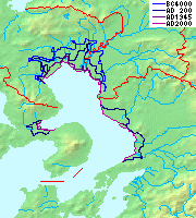
日本語: 海退や堆積、干拓による有明海の海岸線の変遷。海退B.C.4000年頃, A.D.200年頃, 1945年頃, 2000年頃。
English: Map of Ariake sea coastline change by the regression, deposition and land reclamation. Levels around B.C.4000, A.D.200, 1945 and 2000 are shown. |
| Date | |
| Source |
|
| Author | Pekachu |
Licensing

|
Permission is granted to copy, distribute and/or modify this document under the terms of the GNU Free Documentation License, Version 1.2 or any later version published by the Free Software Foundation; with no Invariant Sections, no Front-Cover Texts, and no Back-Cover Texts. A copy of the license is included in the section entitled GNU Free Documentation License. |
| This file is licensed under the Creative Commons Attribution-Share Alike 3.0 Unported license. | ||
| ||
| This licensing tag was added to this file as part of the GFDL licensing update. |
File history
Click on a date/time to view the file as it appeared at that time.
| Date/Time | Thumbnail | Dimensions | User | Comment | |
|---|---|---|---|---|---|
| current | 04:29, 7 April 2006 | | 180 × 200 (22 KB) | Pekachu | *Historical map of Ariake sea(coastline). *有明海の海岸線の変遷 *fromw:ja:画像:Topographic N30E125 5deg.png, w:ja:画像:Topographic N30E130 5deg.png, w:ja:画像:Japan_pref-16c.png. Category:Maps of Japan[[ |
File usage
The following pages on the English Wikipedia use this file (pages on other projects are not listed):
Global file usage
The following other wikis use this file:
- Usage on de.wikipedia.org
- Usage on es.wikipedia.org
- Usage on fr.wikipedia.org
- Usage on id.wikipedia.org
- Usage on ja.wikipedia.org
- Usage on ja.wikibooks.org
- Usage on pl.wikipedia.org
- Usage on th.wikipedia.org