
File:Area map Millas bus accident 2017.png

Size of this preview: 800 × 494 pixels. Other resolutions: 320 × 198 pixels | 640 × 396 pixels | 809 × 500 pixels.
Original file (809 × 500 pixels, file size: 189 KB, MIME type: image/png)
| This is a file from the Wikimedia Commons. Information from its description page there is shown below. Commons is a freely licensed media file repository. You can help. |
Summary
| Description |
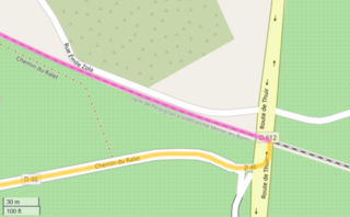
English: Area map of the Perpignan crash of 14 December 2017. On a railroad crossing in Millas near Perpignan, Pyrénées-Orientales, France, a school bus (yellow line) was hit by a regional passenger train (purple line).
Français : Plan de situation de l'accident de Millas (Pyrénées-Orientales) survenu le 14 décembre 2017. Un car scolaire a été percuté par un train express régional (TER) circulant entre Villefranche-de-Conflent et Perpignan. En jaune, le trajet du car ; en violet, le trajet du TER.
Deutsch: Lageplan des Busunfalls von Millas (Département Pyrénées-Orientales, Frankreich) vom 14. Dezember 2017. Ein Schulbus wurde auf einem Bahnübergang mit automatischen Schranken von einem Regionalzug erfasst. Gelbe Linie: Fahrstrecke des Busses, violette Ligne: Fahrstrecke des Zuges. |
| Date | |
| Source |
Own work. English: Base map and data from OpenStreetMap and OpenStreetMap Foundation, map data: OpenStreetMap contributors. Français : Carte de base : OpenStreetMap et Fondation OpenStreetMap ; données cartographiques : contributeurs OpenStreetMap. Deutsch: Kartenhintergrund und -daten von OpenStreetMap und OpenStreetMap Foundation, Kartendaten: Mitwirkende von OpenStreetMap. |
| Author | Yen Zotto |
Licensing
I, the copyright holder of this work, hereby publish it under the following license:
This file is licensed under the Creative Commons Attribution-Share Alike 4.0 International license.
- You are free:
- to share – to copy, distribute and transmit the work
- to remix – to adapt the work
- Under the following conditions:
- attribution – You must give appropriate credit, provide a link to the license, and indicate if changes were made. You may do so in any reasonable manner, but not in any way that suggests the licensor endorses you or your use.
- share alike – If you remix, transform, or build upon the material, you must distribute your contributions under the same or compatible license as the original.
| This work contains information from OpenStreetMap, which is made available under the Open Database License (ODbL).
The ODbL does not require any particular license for maps produced from ODbL data. Prior to 1 August 2020, map tiles produced by the OpenStreetMap Foundation were licensed under the CC-BY-SA-2.0 license. Maps produced by other people may be subject to other licences. |
File history
Click on a date/time to view the file as it appeared at that time.
| Date/Time | Thumbnail | Dimensions | User | Comment | |
|---|---|---|---|---|---|
| current | 14:42, 20 February 2021 | | 809 × 500 (189 KB) | Yen Zotto | {{Information |description ={{en|1=Area map of the bus crash in Millas, Pyrénées-Orientales, France, of 14 December 2017. A school bus (yellow line) was hit by a regional passenger train (purple line) on a railroad crossing.}} {{fr|1=Plan de situation de l'accident de Millas (Pyrénées-Orientales) survenu le 14 décembre 2017. Un car scolaire a été percuté par un train express régional (TER) circulant entre Villefranche-de-Conflent et Perpignan. En jaune, le trajet... |
File usage
The following pages on the English Wikipedia use this file (pages on other projects are not listed):
Global file usage
The following other wikis use this file:
- Usage on de.wikipedia.org
- Usage on fr.wikipedia.org