
File:Aransas National Wildlife Refuge sign.jpg

Size of this preview: 800 × 467 pixels. Other resolutions: 320 × 187 pixels | 640 × 374 pixels | 1,024 × 598 pixels | 1,280 × 747 pixels | 2,560 × 1,495 pixels | 4,606 × 2,689 pixels.
Original file (4,606 × 2,689 pixels, file size: 3.18 MB, MIME type: image/jpeg)
| This is a file from the Wikimedia Commons. Information from its description page there is shown below. Commons is a freely licensed media file repository. You can help. |
Summary
| Description |
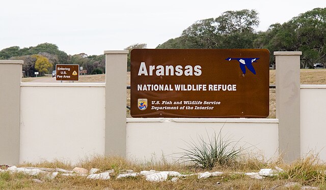
English: Entrance to Aransas National Wildlife Refuge, in Austwell, TX, on Friday, Dec. 16, 2011. Federal and state partners, including representatives from U.S. Fish and Wildlife Service and local soil and water conservation districts (SWCDs) held a press conference at the refuge. U.S. Department of Agriculture (USDA) Natural Resources Conservation Service (NRCS) State Conservationist Salvador Salinas was the keynote speaker; Copano Bay Soil and Water Conservation District Board Member Dallas Ford opened the event; and U.S. Department of the Interior, Fish and Wildlife Service Aransas National Wildlife Refuge Manager Dan Alonso gave background information about the 115,000-acre refuge that was established in 1939. The refuge fresh water comes from the San Antonio River which flows by the historic Alamo southeasterly toward the Guadalupe River at the estuary of San Antonio Bay, the primary body of water for the refuge. Nationally, USDA-NRCS is dedicating up to $50 million over three years to this effort and will continue to provide the proven technical expertise and that of their partners. The anticipated result is improved water quality, stream flows and wildlife habitat. USDA photo by Lance Cheung. |
| Date | |
| Source | 20111216-NRCS-LSC-0003 |
| Author | U.S. Department of Agriculture |
| Camera location | | View this and other nearby images on: OpenStreetMap |
|---|
Licensing
This file is licensed under the Creative Commons Attribution 2.0 Generic license.
- You are free:
- to share – to copy, distribute and transmit the work
- to remix – to adapt the work
- Under the following conditions:
- attribution – You must give appropriate credit, provide a link to the license, and indicate if changes were made. You may do so in any reasonable manner, but not in any way that suggests the licensor endorses you or your use.
| This image was originally posted to Flickr by USDAgov at https://www.flickr.com/photos/41284017@N08/6551530871. It was reviewed on 25 December 2011 by FlickreviewR and was confirmed to be licensed under the terms of the cc-by-2.0. |
This image or file is a work of a United States Department of Agriculture employee, taken or made as part of that person's official duties. As a work of the U.S. federal government, the image is in the public domain.
|
 |
File history
Click on a date/time to view the file as it appeared at that time.
| Date/Time | Thumbnail | Dimensions | User | Comment | |
|---|---|---|---|---|---|
| current | 13:34, 25 December 2011 | | 4,606 × 2,689 (3.18 MB) | BotMultichillT | {{Information |Description=Entrance to Aransas National Wildlife Refuge, in Austwell, TX, on Friday, Dec. 16, 2011. Federal and state partners, including representatives from U.S. Fish and Wildlife Service and local soil and water conservation districts ( |
File usage
The following pages on the English Wikipedia use this file (pages on other projects are not listed):