
File:Araguaia River, between Pará e Tocantins.jpg
Size of this preview: 800 × 450 pixels. Other resolutions: 320 × 180 pixels | 640 × 360 pixels | 1,024 × 576 pixels | 1,280 × 720 pixels | 3,227 × 1,815 pixels.
Original file (3,227 × 1,815 pixels, file size: 3.14 MB, MIME type: image/jpeg)
| This is a file from the Wikimedia Commons. Information from its description page there is shown below. Commons is a freely licensed media file repository. You can help. |
Summary
| Description |
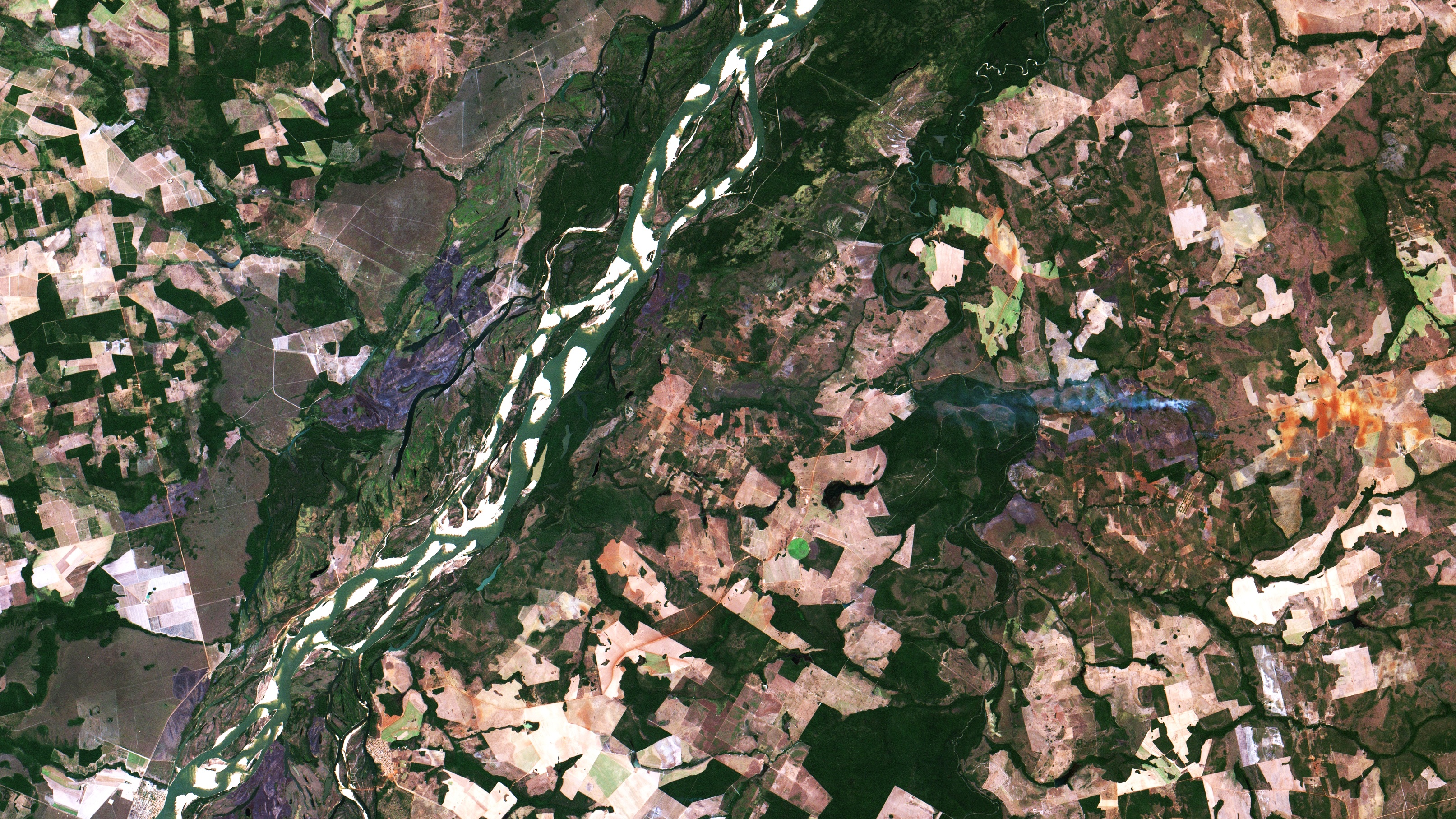
Português: Rio Araguaia, fronteira Pará, a NO, Tocantins, a SE. Municípios de Santana do Araguaia, PA e Caseara, TO. O rio aparece em cor verde claro, praias de areia em branco. Floresta, em verde escuro. Em verde claro e amarronzado, pecuária. Em cinza azulado, à esq. acima do centro da imagem, cicatriz de queimada recente. O círculo verde limão, à dir. embaixo, é um pivô central de irrigação. Em laranja, marrom claro e bege, solo exposto, recém colhido ou preparado para plantio, principalmente de soja / Araguaia river, Brazilian States Para, to the NW, and Tocantins, to SE. Santa do Araguaia and Caseara counties. River appears in light green, sand beaches in white. Forest in dark green. Cattle ranching in light and brownish green. In blueish gray, at image left, above center, is a large recent wildfire burning scar. Lemon green circle, at image bottom right, is a center irrigation pivot. Recently harvested or ready to sow exposed soil appears in orange, light brown and beige, mostly soybeans.
Imagem / Image CBERS4 MUX Rio Araguaia entre o Pará e Tocantins. Coordenadas do centro da imagem / Image center: 9°08'20.6"S 49°52'59.1"W Data / Date: 10-08-2019 / 2019-10-08 RGB765 (cor verdadeira / true color) Cena / Scene: 161 / 110 Autor / Author: Oton Barros (DSR/OBT/INPE) Imagem em HD / HD Image Visite-nos / Visit us: www.dsr.inpe.br |
| Date | |
| Source | https://www.flickr.com/photos/153282474@N02/48530276807/ |
| Author | Coordenação-Geral de Observação da Terra/INPE |
Licensing
This file is licensed under the Creative Commons Attribution-Share Alike 2.0 Generic license.
- You are free:
- to share – to copy, distribute and transmit the work
- to remix – to adapt the work
- Under the following conditions:
- attribution – You must give appropriate credit, provide a link to the license, and indicate if changes were made. You may do so in any reasonable manner, but not in any way that suggests the licensor endorses you or your use.
- share alike – If you remix, transform, or build upon the material, you must distribute your contributions under the same or compatible license as the original.
| This image was originally posted to Flickr by Coordenação-Geral de Observação da Terra/INPE at https://flickr.com/photos/153282474@N02/48530276807. It was reviewed on 9 April 2020 by FlickreviewR 2 and was confirmed to be licensed under the terms of the cc-by-sa-2.0. |
File history
Click on a date/time to view the file as it appeared at that time.
| Date/Time | Thumbnail | Dimensions | User | Comment | |
|---|---|---|---|---|---|
| current | 10:12, 9 April 2020 | | 3,227 × 1,815 (3.14 MB) | Jo-Jo Eumerus | Uploaded a work by Coordenação-Geral de Observação da Terra/INPE from https://www.flickr.com/photos/153282474@N02/48530276807/ with UploadWizard |
File usage
The following pages on the English Wikipedia use this file (pages on other projects are not listed):
Global file usage
The following other wikis use this file:
- Usage on pt.wikipedia.org