
File:Aragats aerial.jpg

Size of this preview: 800 × 532 pixels. Other resolutions: 320 × 213 pixels | 640 × 425 pixels | 1,024 × 680 pixels | 1,280 × 850 pixels | 2,977 × 1,978 pixels.
Original file (2,977 × 1,978 pixels, file size: 5.52 MB, MIME type: image/jpeg)
| This is a file from the Wikimedia Commons. Information from its description page there is shown below. Commons is a freely licensed media file repository. You can help. |
Summary
| Description |
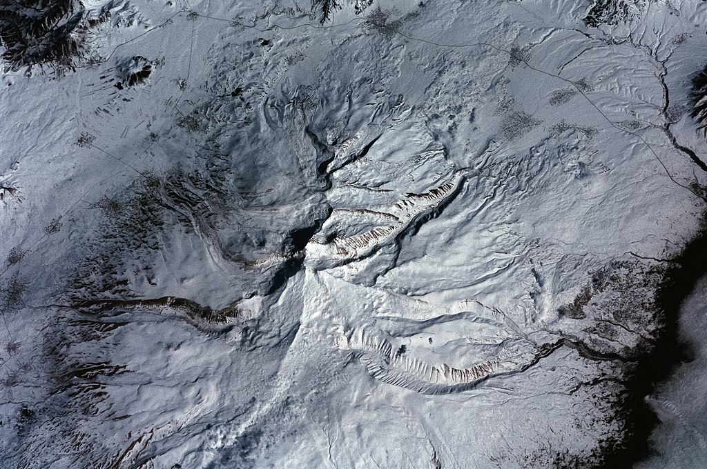
English: Mount Aragats, aerial view. |
| Date | |
| Source | JSC Gateway to Astronaut Photography of Earth |
| Author | Earth Science and Remote Sensing Unit, Lyndon B. Johnson Space Center |
| Mission | ISS001 |
| Roll | 346 |
| Frame | 24 |
| Geographic area | Armenia |
| Features | MOUNT ARAGATS, SNOW |
| Cloud percentage | 10% |
| Altitude | 198 nautical miles (367 km) |
| Look angle | 35° |
| Look direction | N |
| Sun Azimuth | 200° |
| Sun Elevation | 42° |
| Camera | Nikon 35mm film camera |
| Object location | | View this and other nearby images on: OpenStreetMap |
|---|
| Camera location | | View this and other nearby images on: OpenStreetMap |
|---|
This image or video was catalogued by Johnson Space Center of the United States National Aeronautics and Space Administration (NASA) under Photo ID: ISS004-E-10651. This tag does not indicate the copyright status of the attached work. A normal copyright tag is still required. See Commons:Licensing. Other languages:
|
Licensing
| This file is in the public domain in the United States because it was solely created by NASA. NASA copyright policy states that "NASA material is not protected by copyright unless noted". (See Template:PD-USGov, NASA copyright policy page or JPL Image Use Policy.) | ||
 |
Warnings:
|
File history
Click on a date/time to view the file as it appeared at that time.
| Date/Time | Thumbnail | Dimensions | User | Comment | |
|---|---|---|---|---|---|
| current | 09:52, 6 June 2022 | | 2,977 × 1,978 (5.52 MB) | Askeuhd | corrected version based on raw scan |
| 09:05, 7 May 2016 |  | 2,965 × 1,972 (1.03 MB) | Yerevantsi | cropped & enhanced | |
| 07:50, 7 May 2016 |  | 3,070 × 2,044 (599 KB) | Yerevantsi | higher resolution | |
| 13:12, 25 September 2004 |  | 375 × 260 (49 KB) | Robbot | This image was copied from en.wikipedia.org. The original description was: Mount Aragats, aerial view. Taken from Earth Sciences and Image Analysis, NASA-Johnson Space Center (image ref. ISS004-E-10651). <br />http://eol.jsc.nasa.gov/scripts/sseop/phot |
File usage
The following pages on the English Wikipedia use this file (pages on other projects are not listed):
Global file usage
The following other wikis use this file:
- Usage on af.wikipedia.org
- Usage on ba.wikipedia.org
- Usage on bcl.wikipedia.org
- Usage on bg.wikipedia.org
- Usage on de.wikipedia.org
- Usage on es.wikipedia.org
- Usage on fa.wikipedia.org
- Usage on gl.wikipedia.org
- Usage on hy.wikipedia.org
- Usage on nn.wikipedia.org
- Usage on os.wikipedia.org
- Usage on ru.wikipedia.org
- Usage on sr.wikipedia.org