
File:Arabi20FebLeBeau1.jpg
Size of this preview: 800 × 462 pixels. Other resolutions: 320 × 185 pixels | 640 × 369 pixels | 1,024 × 591 pixels | 1,280 × 738 pixels | 2,432 × 1,403 pixels.
Original file (2,432 × 1,403 pixels, file size: 984 KB, MIME type: image/jpeg)
| This is a file from the Wikimedia Commons. Information from its description page there is shown below. Commons is a freely licensed media file repository. You can help. |
Summary
| Description |
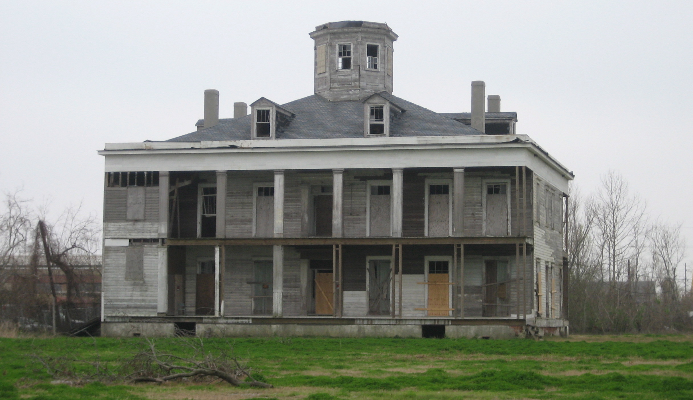
English: LeBeau Plantation, Arabi, Louisiana. The 1854 plantation house, Photographed by Infrogmation of New Orleans in 2006. It was a hotel and gambling establishment in the mid 20th century, destroyed by arson in 2013. The property was owned by Joseph Meraux and in his will was left to Arlene Soper Meraux after a court battle to prove a common law marriage. After her death, months prior to Hurricane Katrina, she left this plantation and several other properties to a commission made of several St. Bernard Parish politicians. Before the storm and later arson, a committee had planned on making large and pricey renovations to Le Beau hoping to bring more tourism into the area.
|
||
| Date | |||
| Source | Photo by Infrogmation of New Orleans | ||
| Author | Infrogmation of New Orleans | ||
| Permission (Reusing this file) |
May be reused with photographer attribution in accordance with any of the licenses listed by the author. Reuse without attribution is a violation of copyright. |
Licensing
I, the copyright holder of this work, hereby publish it under the following licenses:

|
Permission is granted to copy, distribute and/or modify this document under the terms of the GNU Free Documentation License, Version 1.2 or any later version published by the Free Software Foundation; with no Invariant Sections, no Front-Cover Texts, and no Back-Cover Texts. A copy of the license is included in the section entitled GNU Free Documentation License. |
This file is licensed under the Creative Commons Attribution 2.5 Generic license.
- You are free:
- to share – to copy, distribute and transmit the work
- to remix – to adapt the work
- Under the following conditions:
- attribution – You must give appropriate credit, provide a link to the license, and indicate if changes were made. You may do so in any reasonable manner, but not in any way that suggests the licensor endorses you or your use.
You may select the license of your choice.
| Object location | | View this and other nearby images on: OpenStreetMap |
|---|
File history
Click on a date/time to view the file as it appeared at that time.
| Date/Time | Thumbnail | Dimensions | User | Comment | |
|---|---|---|---|---|---|
| current | 02:04, 24 March 2006 | | 2,432 × 1,403 (984 KB) | Infrogmation | Le Beau plantation house, Arabi Louisiana. The 1854 planation house was a hotel and gambling establishment in the mid 20th century, and has long been vacant. Photo by ~~~ Category:Houses in Louisiana Category:Plantation houses [[Category:Saint B |
File usage
The following pages on the English Wikipedia use this file (pages on other projects are not listed):
Global file usage
The following other wikis use this file:
- Usage on ar.wikipedia.org
- Usage on ca.wikipedia.org
- Usage on ceb.wikipedia.org
- Usage on ce.wikipedia.org
- Usage on en.wikivoyage.org
- Usage on es.wikipedia.org
- Usage on fr.wikipedia.org
- Usage on it.wikipedia.org
- Usage on lld.wikipedia.org
- Usage on pl.wikipedia.org
- Usage on pt.wikipedia.org
- Usage on sr.wikipedia.org
- Usage on tt.wikipedia.org
- Usage on uk.wikipedia.org
- Usage on www.wikidata.org