
File:Aquitani tribes map-fr.svg

Size of this PNG preview of this SVG file: 702 × 600 pixels. Other resolutions: 281 × 240 pixels | 562 × 480 pixels | 899 × 768 pixels | 1,199 × 1,024 pixels | 2,398 × 2,048 pixels | 878 × 750 pixels.
Original file (SVG file, nominally 878 × 750 pixels, file size: 1.26 MB)
| This is a file from the Wikimedia Commons. Information from its description page there is shown below. Commons is a freely licensed media file repository. You can help. |

Summary
| Description |
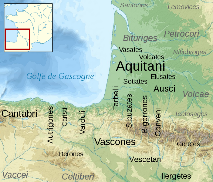
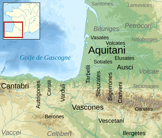
English: Map of the Aquitani and surrounding tribes in early Roman times.
Français : Carte des peuples de la Gaule Aquitaine au début de l'époque romaine.
|
||
| Date | |||
| Source |
|
||
| Author | Sémhur | ||
| Other versions | |||
| Attribution (required by the license) | © Sémhur / Wikimedia Commons / | ||
| SVG | W3C-validity not checked.
|
||
| Graphic Lab |

| Camera location | | View this and other nearby images on: OpenStreetMap |
|---|
Licensing
I, the copyright holder of this work, hereby publish it under the following licenses:
| Copyleft: This work of art is free; you can redistribute it and/or modify it according to terms of the Free Art License. You will find a specimen of this license on the Copyleft Attitude site as well as on other sites. |
This file is licensed under the Creative Commons Attribution-Share Alike 4.0 International, 3.0 Unported, 2.5 Generic, 2.0 Generic and 1.0 Generic license.
- You are free:
- to share – to copy, distribute and transmit the work
- to remix – to adapt the work
- Under the following conditions:
- attribution – You must give appropriate credit, provide a link to the license, and indicate if changes were made. You may do so in any reasonable manner, but not in any way that suggests the licensor endorses you or your use.
- share alike – If you remix, transform, or build upon the material, you must distribute your contributions under the same or compatible license as the original.
You may select the license of your choice.
Original upload log
This image is a derivative work of the following images:
- File:France_map_Lambert-93_topographic-blank.svg licensed with Cc-by-sa-3.0,2.5,2.0,1.0, GFDL
- 2008-11-13T17:24:53Z Sting 2000x1898 (1639447 Bytes) + boundary for Channel Islands ; - canals
- 2008-10-01T04:59:44Z Sting 2000x1898 (1682809 Bytes) == Summary == {{Location|46|15|00|N|02|06|00|E|scale:10000000}} {{Information |Description={{en|Blank topographic map of [[:en:France|France]] in the official Lambert-93 projection.}} {{fr|Carte topographique vierge de la [[
- File:Aquitani.gif licensed with PD-self
- 2007-01-25T14:16:29Z Michel BUZE 481x393 (10166 Bytes) {{Information |Description= *Author: [[:en:User:Sugaar|Sugaar]] *Sources: various (ultimately [[:en:Strabo]] and [[:en:Pliny]]) *Based on [[:en::Image:Basque tribes.gif]] (the only diference is that it tags the Aquitani confe
- File:Blank_map_of_Gaul_1st_century_BC.svg licensed with Cc-by-sa-2.5,2.0,1.0, GFDL
- 2007-07-07T19:30:39Z Historicair 755x784 (45078 Bytes) {{Information |Description={{fr}}Carte vierge de la Gaule au Ier siècle avant JC {{en}}Blank map of Gaul 1st century BC. |Source=[[:Image:Caesar's Campaigns in Gaul, 1st century BC.gif]] |Date=07/07/2007 |Author=~~~~ |Permis
Uploaded with derivativeFX
File history
Click on a date/time to view the file as it appeared at that time.
| Date/Time | Thumbnail | Dimensions | User | Comment | |
|---|---|---|---|---|---|
| current | 15:46, 17 February 2009 | | 878 × 750 (1.26 MB) | Sémhur | {{Information |Description= {{en|Map of the Aquitani and surrounding tribes in early Roman times. * Black: pre-Indoeuropean tribes. * Grey: Celtic tribes. ''Note: the macro-ethnicity of some of the tribes is disputed.''}} {{fr|Carte des peuples de la Ga |
File usage
The following pages on the English Wikipedia use this file (pages on other projects are not listed):
Global file usage
The following other wikis use this file:
- Usage on an.wikipedia.org
- Usage on azb.wikipedia.org
- Usage on az.wikipedia.org
- Usage on bg.wikipedia.org
- Usage on br.wikipedia.org
- Usage on ca.wikipedia.org
- Usage on de.wikipedia.org
- Usage on el.wikipedia.org
- Usage on en.wiktionary.org
- Usage on eo.wikipedia.org
- Usage on eu.wikipedia.org
- Usage on fi.wikipedia.org
- Usage on fr.wikipedia.org
View more global usage of this file.