
File:Approximate apportionment of visitor sources for Delaware Water Gap National Recreation Area.png
Size of this preview: 333 × 599 pixels. Other resolutions: 133 × 240 pixels | 359 × 646 pixels.
Original file (359 × 646 pixels, file size: 312 KB, MIME type: image/png)
| This is a file from the Wikimedia Commons. Information from its description page there is shown below. Commons is a freely licensed media file repository. You can help. |
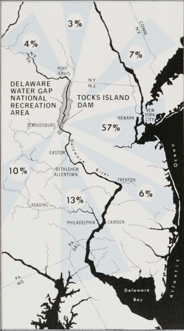
Summary
| Description |
English: Approximate apportionment of visitor sources for Delaware Water Gap National Recreation Area as part of the Tocks Island Dam proposal in the 1960s. The proposed recreation preserve was expected to accommodate 10.5 million annual visitors. |
| Date | between circa 1962 and circa 1974 |
| Source | https://usace.contentdm.oclc.org/digital/api/collection/p16021coll4/id/114/download |
| Author | U.S. Army Corps of Engineers |
Licensing
This image or file is a work of a U.S. Army Corps of Engineers soldier or employee, taken or made as part of that person's official duties. As a work of the U.S. federal government, the image is in the public domain.
|
File history
Click on a date/time to view the file as it appeared at that time.
| Date/Time | Thumbnail | Dimensions | User | Comment | |
|---|---|---|---|---|---|
| current | 18:28, 10 June 2021 | | 359 × 646 (312 KB) | Z22 | Uploaded a work by U.S. Army Corps of Engineers from https://usace.contentdm.oclc.org/digital/api/collection/p16021coll4/id/114/download with UploadWizard |
File usage
The following pages on the English Wikipedia use this file (pages on other projects are not listed):