
File:Antenne Oméga - Ile de la Réunion.png

Size of this preview: 402 × 600 pixels. Other resolutions: 161 × 240 pixels | 322 × 480 pixels | 1,013 × 1,511 pixels.
Original file (1,013 × 1,511 pixels, file size: 1.67 MB, MIME type: image/png)
| This is a file from the Wikimedia Commons. Information from its description page there is shown below. Commons is a freely licensed media file repository. You can help. |
Summary
| Description |
Français : Antenne Oméga E
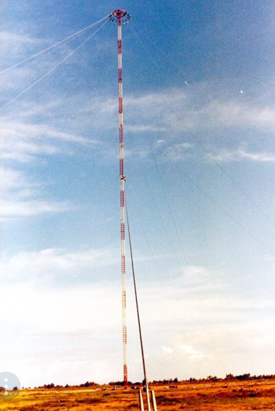
English: Antenna of the Chabrier Omega Transmitter (station E ) an obsolete electronic navigation system, near Chabrier on Réunion island in the Indian Ocean. It was one of 9 worldwide stations of the Omega navigation system, which transmitted on 10 - 14 kHz in the VLF frequency band. It consists of an umbrella antenna, installed on a 428-meter grounded guyed mast. The mast was demolished with explosives on 14 April 1999. |
| Date | |
| Source | Anciens cols Bleus et Pompons Rouges |
| Author | Anciens cols Bleus et Pompons Rouges |
Licensing
| This file is made available under the Creative Commons CC0 1.0 Universal Public Domain Dedication. | |
| The person who associated a work with this deed has dedicated the work to the public domain by waiving all of their rights to the work worldwide under copyright law, including all related and neighboring rights, to the extent allowed by law. You can copy, modify, distribute and perform the work, even for commercial purposes, all without asking permission.
|
File history
Click on a date/time to view the file as it appeared at that time.
| Date/Time | Thumbnail | Dimensions | User | Comment | |
|---|---|---|---|---|---|
| current | 18:56, 26 December 2017 | | 1,013 × 1,511 (1.67 MB) | A340run | User created page with UploadWizard |
File usage
The following pages on the English Wikipedia use this file (pages on other projects are not listed):
Global file usage
The following other wikis use this file:
- Usage on de.wikipedia.org
- Usage on fr.wikipedia.org