
File:Ancient Parish of Rochdale.png
Size of this preview: 578 × 600 pixels. Other resolutions: 231 × 240 pixels | 462 × 480 pixels | 740 × 768 pixels | 986 × 1,024 pixels | 1,892 × 1,964 pixels.
Original file (1,892 × 1,964 pixels, file size: 547 KB, MIME type: image/png)
| This is a file from the Wikimedia Commons. Information from its description page there is shown below. Commons is a freely licensed media file repository. You can help. |
Summary
| Description |
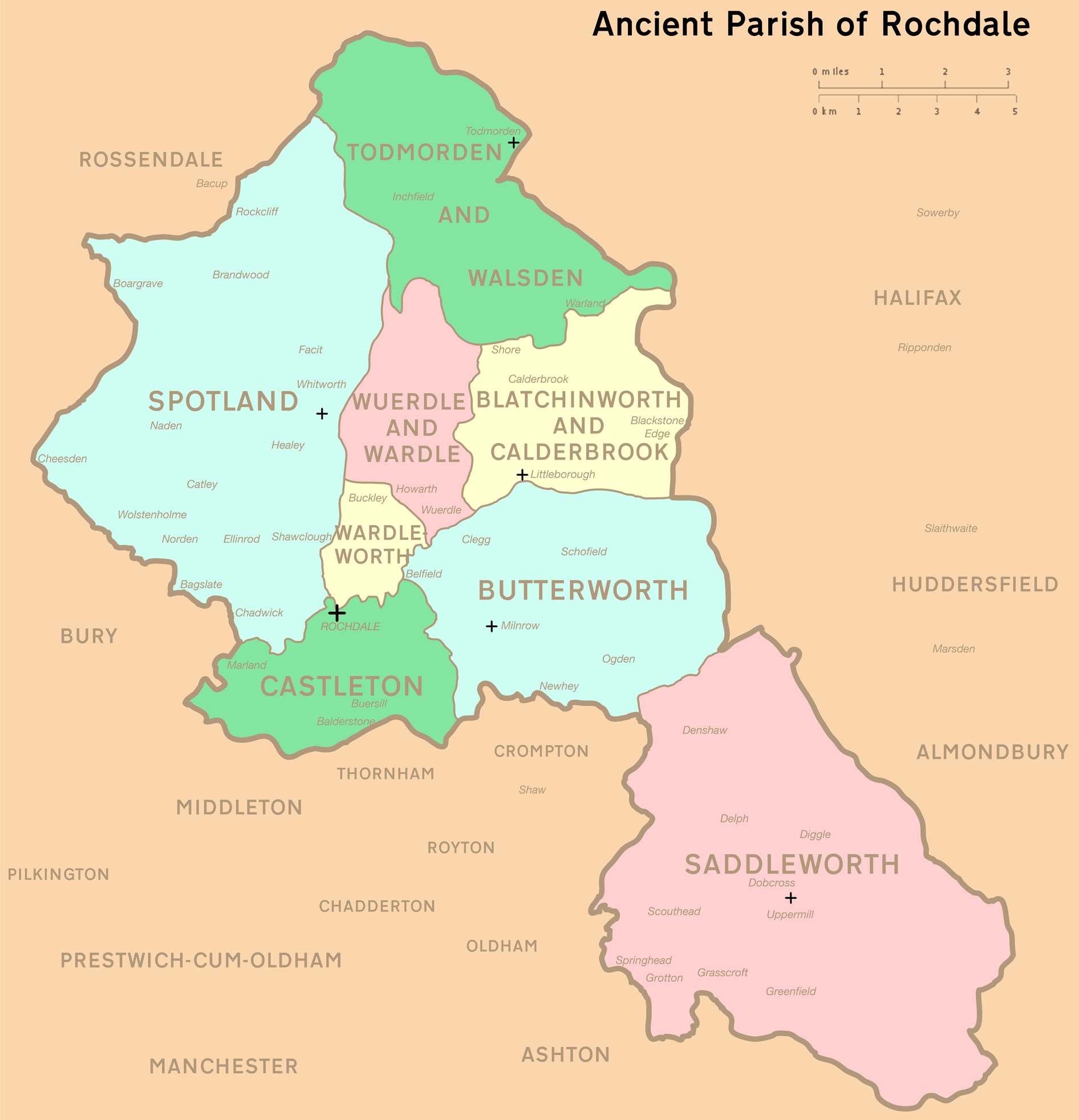
English: A map of the former parish of Rochdale, an ancient ecclesiastical territory which straddled Lancashire and the West Riding of Yorkshire, in northern England.
The eight coloured units represent the administrative subdivisions of the parish as they appeared during the Early Modern Period. They were:
A black cross represents the location of a Christian place of worship. Surrounding townships and parishes are marked accordingly. Prior to local government reforms in the 19th century, the market town of Rochdale predominantly occupied parts of Castleton and Wardleworth, but later expanded into Spotland, Butterworth and Wuerdle. |
| Date | |
| Source | Own work. Adapted from Farrer & Brownbill (1911), The Victoria history of the county of Lancaster, Vol 5 p. 187 -201. |
| Author | Jza84 |
Licensing
I, the copyright holder of this work, hereby publish it under the following licenses:
This file is licensed under the Creative Commons Attribution-Share Alike 3.0 Unported license.
- You are free:
- to share – to copy, distribute and transmit the work
- to remix – to adapt the work
- Under the following conditions:
- attribution – You must give appropriate credit, provide a link to the license, and indicate if changes were made. You may do so in any reasonable manner, but not in any way that suggests the licensor endorses you or your use.
- share alike – If you remix, transform, or build upon the material, you must distribute your contributions under the same or compatible license as the original.

|
Permission is granted to copy, distribute and/or modify this document under the terms of the GNU Free Documentation License, Version 1.2 or any later version published by the Free Software Foundation; with no Invariant Sections, no Front-Cover Texts, and no Back-Cover Texts. A copy of the license is included in the section entitled GNU Free Documentation License. |
You may select the license of your choice.
File history
Click on a date/time to view the file as it appeared at that time.
| Date/Time | Thumbnail | Dimensions | User | Comment | |
|---|---|---|---|---|---|
| current | 12:02, 20 July 2010 | | 1,892 × 1,964 (547 KB) | Jza84 | altering pixel total to generate image |
| 11:58, 20 July 2010 |  | 4,124 × 4,329 (625 KB) | Jza84 | {{Information |Description={{en|1=A map of the former parish of Rochdale, an ancient ecclesiastical territory which straddled Lancashire and the West Riding of Yorkshire, in northern England. The eight coloured units represent the administrative subdivis |
File usage
The following pages on the English Wikipedia use this file (pages on other projects are not listed):