
File:Allied lines of communication in Southeast Asia, 1942-43.jpg
Size of this preview: 779 × 600 pixels. Other resolutions: 312 × 240 pixels | 624 × 480 pixels | 998 × 768 pixels | 1,260 × 970 pixels.
Original file (1,260 × 970 pixels, file size: 450 KB, MIME type: image/jpeg)
| This is a file from the Wikimedia Commons. Information from its description page there is shown below. Commons is a freely licensed media file repository. You can help. |

|
This historical map image could be re-created using vector graphics as an SVG file. This has several advantages; see Commons:Media for cleanup for more information. If an SVG form of this image is available, please upload it and afterwards replace this template with
{{vector version available|new image name}}.
It is recommended to name the SVG file “Allied lines of communication in Southeast Asia, 1942-43.svg”—then the template Vector version available (or Vva) does not need the new image name parameter. |


Summary
| Description |
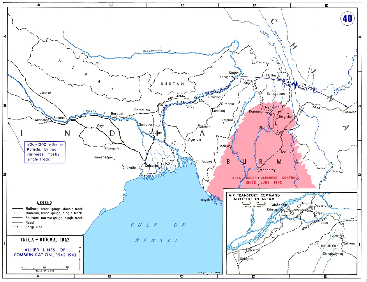
English: Allied lines of communication in India, Burma, and China in 1942–43. |
| Date | Unknown date |
| Source | [1] |
| Author | The Department of History, United States Military Academy |
| Permission (Reusing this file) |
In the public domain as an original work of the United States federal government and/or military [2] |
Licensing
This work is in the public domain in the United States because it is a work prepared by an officer or employee of the United States Government as part of that person’s official duties under the terms of Title 17, Chapter 1, Section 105 of the US Code.
Note: This only applies to original works of the Federal Government and not to the work of any individual U.S. state, territory, commonwealth, county, municipality, or any other subdivision. This template also does not apply to postage stamp designs published by the United States Postal Service since 1978. (See § 313.6(C)(1) of Compendium of U.S. Copyright Office Practices). It also does not apply to certain US coins; see The US Mint Terms of Use.
|
 | |
| This file has been identified as being free of known restrictions under copyright law, including all related and neighboring rights. | ||
File history
Click on a date/time to view the file as it appeared at that time.
| Date/Time | Thumbnail | Dimensions | User | Comment | |
|---|---|---|---|---|---|
| current | 17:02, 29 December 2013 | | 1,260 × 970 (450 KB) | Hohum | Cleanup |
| 02:16, 30 August 2006 |  | 1,260 × 970 (176 KB) | Kirill Lokshin | {{Information |Description= Allied lines of communication in India, Burma, and China in 1942–43. |Source= [http://www.dean.usma.edu/history/web03/atlases/ww2%20pacific/ww2%20pacific%20%20pages/ww2%20pacific%20map%2040.htm] |Date= ? |Author= [http://www |
File usage
The following pages on the English Wikipedia use this file (pages on other projects are not listed):
Global file usage
The following other wikis use this file:
- Usage on ast.wikipedia.org
- Usage on as.wikipedia.org
- Usage on da.wikipedia.org
- Usage on de.wikipedia.org
- Usage on es.wikipedia.org
- Usage on fa.wikipedia.org
- Usage on fr.wikipedia.org
- Usage on gu.wikipedia.org
- Usage on he.wikipedia.org
- Usage on hi.wikipedia.org
- Usage on hr.wikipedia.org
- Usage on id.wikipedia.org
- Usage on it.wikipedia.org
- Usage on ja.wikipedia.org
- Usage on lv.wikipedia.org
- Usage on my.wikipedia.org
- Usage on nl.wikipedia.org
- Usage on no.wikipedia.org
- Usage on pt.wikipedia.org
- Usage on ru.wikipedia.org
- Usage on sh.wikipedia.org
- Usage on www.wikidata.org
- Usage on zh.wikipedia.org