
File:Alexander County Map in 1854.jpg
No higher resolution available.
Alexander_County_Map_in_1854.jpg (338 × 351 pixels, file size: 84 KB, MIME type: image/jpeg)
| This is a file from the Wikimedia Commons. Information from its description page there is shown below. Commons is a freely licensed media file repository. You can help. |
Summary
| Description |
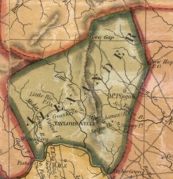
English: Alexander County Map from North Carolina Map by Wellington Williams created in 1854 for the North Carolina Legislature. Shows boundaries, cities and towns, churches, mills, principal roads, plank roads, railroads, gold mines, and natural features. |
| Date | |
| Source | https://www.loc.gov/resource/g3900.ct003170/?r=0.201,0.072,0.298,0.104,0 |
| Author | Williams, W. (Wellington) |
Licensing
This work is in the public domain in the United States because it was published (or registered with the U.S. Copyright Office) before January 1, 1929.
Public domain works must be out of copyright in both the United States and in the source country of the work in order to be hosted on the Commons. If the work is not a U.S. work, the file must have an additional copyright tag indicating the copyright status in the source country.
Note: This tag should not be used for sound recordings. |
File history
Click on a date/time to view the file as it appeared at that time.
| Date/Time | Thumbnail | Dimensions | User | Comment | |
|---|---|---|---|---|---|
| current | 13:03, 8 August 2019 | | 338 × 351 (84 KB) | G. Moore | User created page with UploadWizard |
File usage
The following pages on the English Wikipedia use this file (pages on other projects are not listed):