
File:Al-Khwarizmi's map.png
No higher resolution available.
Al-Khwarizmi's_map.png (371 × 268 pixels, file size: 72 KB, MIME type: image/png)
Summary[edit]
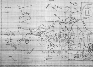
Caption: The section of al-Khwarizmi's world map concerning the Indian Ocean from the east coast of Africa to the Malay Peninsula and beyond, including the semi-legendary Isle of the Jewel. Source: http://www.cristobalcolondeibiza.com/2eng/2eng12.htm#pto05
Fair use rationale[edit]
- This image is used to illustrate the object in question, namely Hubert Dauntich's reconstruction of al-Khwarizmi's map.
- This image is of a very low quality.
Modifications: Heightened contrast
Licensing[edit]
 | This work is copyrighted (or assumed to be copyrighted) and unlicensed. It does not fall into one of the blanket acceptable non-free content categories listed at Wikipedia:Non-free content § Images or Wikipedia:Non-free content § Audio clips, and it is not covered by a more specific non-free content license listed at Category:Wikipedia non-free file copyright templates. However, it is believed that the use of this work:
qualifies as fair use under United States copyright law. Any other uses of this image, on Wikipedia or elsewhere, may be copyright infringement. See Wikipedia:Non-free content and Wikipedia:Copyrights. |
File history
Click on a date/time to view the file as it appeared at that time.
| Date/Time | Thumbnail | Dimensions | User | Comment | |
|---|---|---|---|---|---|
| current | 00:20, 30 May 2017 | | 371 × 268 (72 KB) | DatBot (talk | contribs) | Reduce size of non-free image (BOT - disable) |
| 02:22, 15 March 2006 | No thumbnail | 600 × 435 (166 KB) | Ruud Koot (talk | contribs) |
You cannot overwrite this file.
File usage
The following pages on the English Wikipedia use this file (pages on other projects are not listed):