
File:Air Traffic Control, RAF Topcliffe - geograph.org.uk - 430545.jpg
No higher resolution available.
Air_Traffic_Control,_RAF_Topcliffe_-_geograph.org.uk_-_430545.jpg (640 × 488 pixels, file size: 56 KB, MIME type: image/jpeg)
| This is a file from the Wikimedia Commons. Information from its description page there is shown below. Commons is a freely licensed media file repository. You can help. |
Summary
| Description |
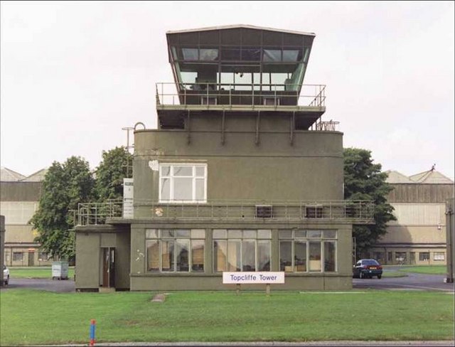
English: Air Traffic Control, RAF Topcliffe The RAF still has a presence at Topcliffe. The airfield acts as a Relief Landing Ground for RAF Linton-on-Ouse and sits in an enclave inside Alanbrooke Barracks. The 'Topcliffe Tower' sign on the grass in front of the tower, is from a now demolished tower block in Castle Vale, in the West Midlands. |
| Date | |
| Source | From geograph.org.uk |
| Author | Frank Glover |
| Attribution (required by the license) | Frank Glover / Air Traffic Control, RAF Topcliffe / |
| Camera location | | View this and other nearby images on: OpenStreetMap |
|---|
_heading:292.00&language=en)
| Object location | | View this and other nearby images on: OpenStreetMap |
|---|
_heading:292.00&language=en)
Licensing

|
This image was taken from the Geograph project collection. See this photograph's page on the Geograph website for the photographer's contact details. The copyright on this image is owned by Frank Glover and is licensed for reuse under the Creative Commons Attribution-ShareAlike 2.0 license.
|
This file is licensed under the Creative Commons Attribution-Share Alike 2.0 Generic license.
Attribution: Frank Glover
- You are free:
- to share – to copy, distribute and transmit the work
- to remix – to adapt the work
- Under the following conditions:
- attribution – You must give appropriate credit, provide a link to the license, and indicate if changes were made. You may do so in any reasonable manner, but not in any way that suggests the licensor endorses you or your use.
- share alike – If you remix, transform, or build upon the material, you must distribute your contributions under the same or compatible license as the original.
File history
Click on a date/time to view the file as it appeared at that time.
| Date/Time | Thumbnail | Dimensions | User | Comment | |
|---|---|---|---|---|---|
| current | 07:00, 4 February 2011 | | 640 × 488 (56 KB) | GeographBot | == {{int:filedesc}} == {{Information |description={{en|1=Air Traffic Control, RAF Topcliffe The RAF still has a presence at Topcliffe. The airfield acts as a Relief Landing Ground for RAF Linton-on-Ouse and sits in an enclave inside Alanbrooke Barracks. T |
File usage
The following pages on the English Wikipedia use this file (pages on other projects are not listed):
Global file usage
The following other wikis use this file:
- Usage on es.wikipedia.org
- Usage on fr.wikipedia.org
- Usage on sv.wikipedia.org
- Usage on www.wikidata.org