
File:Adrar Departments2.png
No higher resolution available.
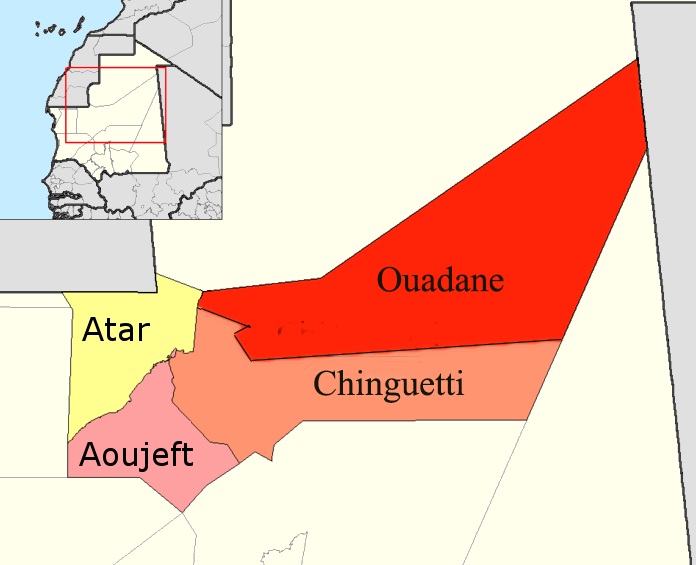
Adrar_Departments2.png (696 × 565 pixels, file size: 83 KB, MIME type: image/png)
| This is a file from the Wikimedia Commons. Information from its description page there is shown below. Commons is a freely licensed media file repository. You can help. |
Summary
| Description |
English: Map of the departments of Adrar region of Mauritania. Adapted by User:McTrixie using GIMP, from en:Image:Adrar departments.png created by Rarelibra and from en:Image:Adrar Departments.png by User McTrixie. Summary of changes to original image: two simple enlargements of the names on the map; redone a second time because the names on the map were still small. |
| Date | 29 April 2007 (original upload date) |
| Source | Transferred from en.wikipedia to Commons by Gikü. |
| Author | The original uploader was McTrixie at English Wikipedia. |
| Other versions |
 |
Licensing

|
Permission is granted to copy, distribute and/or modify this document under the terms of the GNU Free Documentation License, Version 1.2 or any later version published by the Free Software Foundation; with no Invariant Sections, no Front-Cover Texts, and no Back-Cover Texts. A copy of the license is included in the section entitled GNU Free Documentation License. |
| This file is licensed under the Creative Commons Attribution-Share Alike 3.0 Unported license. | ||
| ||
| This licensing tag was added to this file as part of the GFDL licensing update. |
Original upload log
The original description page was here. All following user names refer to en.wikipedia.
- 2007-04-29 15:48 McTrixie 776×600× (71024 bytes) Map of the departments of Adrar region of Mauritania. Adapted by User:McTrixie using GIMP, from Image:Adrar departments.png created by Rarelibra. Summary of changes to original image: a simple enlargement of the names on the map, which were so tiny as to
File history
Click on a date/time to view the file as it appeared at that time.
| Date/Time | Thumbnail | Dimensions | User | Comment | |
|---|---|---|---|---|---|
| current | 08:49, 19 November 2019 | | 696 × 565 (83 KB) | Clemens Schmillen | Contains all departments of the Adrar Region |
| 12:17, 19 August 2015 |  | 696 × 565 (47 KB) | Naturals | colors | |
| 18:48, 15 December 2008 |  | 776 × 600 (69 KB) | Gikü | {{Information |Description={{en|Map of the departments of Adrar region of Mauritania. Adapted by User:McTrixie using GIMP, from [[:en::Image:Adrar departments.png]] created by Rarelibra and from [[:en::Image:Adrar Departments.png]] by User McTrixie. Summa |
File usage
The following pages on the English Wikipedia use this file (pages on other projects are not listed):
Global file usage
The following other wikis use this file:
- Usage on ar.wikipedia.org
- Usage on be.wikipedia.org
- Usage on da.wikipedia.org
- Usage on de.wikipedia.org
- Usage on eo.wikipedia.org
- Usage on es.wikipedia.org
- Usage on frr.wikipedia.org
- Usage on fr.wikipedia.org
- Usage on it.wikipedia.org
- Usage on ja.wikipedia.org
- Usage on lt.wikipedia.org
- Usage on pt.wikipedia.org
- Usage on ro.wikipedia.org
- Usage on ru.wikipedia.org
- Usage on si.wikipedia.org
- Usage on sv.wikipedia.org
- Usage on uk.wikipedia.org