
File:Able1952 map.PNG
No higher resolution available.
Able1952_map.PNG (542 × 536 pixels, file size: 195 KB, MIME type: image/png)
| This is a file from the Wikimedia Commons. Information from its description page there is shown below. Commons is a freely licensed media file repository. You can help. |
| Description |
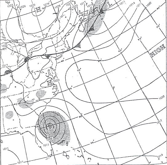
English: Surface weather map for 1230 GMT, August 30, 1952. Shading indicates areas of active precipitation
Hurricane Able is seen at the bottom of the image, about to strike South Carolina |
|||
| Date | ||||
| Source | http://www.aoml.noaa.gov/general/lib/lib1/nhclib/mwreviews/1952.pdf | |||
| Author | U.S. Weather Bureau | |||
| Permission (Reusing this file) |
|
File history
Click on a date/time to view the file as it appeared at that time.
| Date/Time | Thumbnail | Dimensions | User | Comment | |
|---|---|---|---|---|---|
| current | 19:15, 13 January 2011 | | 542 × 536 (195 KB) | Hurricanehink | {{Information |Description={{en|1=Surface weather map for 1230 GMT, August 30, 1952. Shading indicates areas of active precipitation Hurricane Able is seen at the bottom of the image, about to strike South Carolina}} |Source=http://www.aoml.noaa.gov/gene |
File usage
The following pages on the English Wikipedia use this file (pages on other projects are not listed):
Global file usage
The following other wikis use this file:
- Usage on pt.wikipedia.org
- Usage on www.wikidata.org