File:A pocket companion of Ireland, containing all the cities, market towns, boroughs, all ye great roads, and principal cross roads with the computed miles from town to town (5375550325).jpg

Page contents not supported in other languages.
This is a file from the Wikimedia Commons
From Wikipedia, the free encyclopedia

Original file(7,044 × 7,743 pixels, file size: 12.43 MB, MIME type: image/jpeg)

Summary

Description

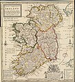
A map of Ireland c. 1732 with cities, bishoprics, boroughs, market towns and villages, "small barracks", bogs, and roads marked.

Title: A Pocket Companion of ye Roads of Ireland, Containing all the Cities, Market-Towns, Boroughs, All ye Great Roads, and Principal Cross Roads with the Computed Miles from Town to Town

Notes: The Number of Inhabitants in Ireland are Computed at 1.000000. Dublin the Chief City is 268 miles distant from London.

The Area of ye Provinces of Ireland is given in Square Miles. Ulster 7200 Sqr. M. Connaught 6072 S. M. Leinster 6120 Sqr. M. Munster 8065 Sq. M. Sum Total 27,457.

To His Grace Charles Duke of Grafton Lord Leutenant of Ireland, Knight of ye most Noble order of ye Garter &c. This Map is Humbly Dedicated by your Grace's Ob. Servt. H. Moll G.

Sold by T. Bowles next ye Chapter House in S. Pauls Church yard & I. Bowles at ye Black Horse in Cornhill.

Scale in "British miles" (i.e., English) and "Irish miles" set at the same value as the "Scottish miles" elsewhere, 50 to a degree versus the 60 to a degree used for the English miles.

Dimensions: 29×27 cm

Scale: c. 1:1,700,000


Date
Source Norman Bleventhal Map Center Flickr account, an image of a copy of the map (G5780 1732 .M66x) held by the Boston Public Library. The map was originally sold separately or as page 12 in Moll's Atlas Minor.
Author
Herman Moll  (1654–1732)  wikidata:Q1610319
 
Herman Moll
Alternative names
Moll, Hermann
Description British cartographer, engraver and publisher
Date of birth/death circa 1654
date QS:P,+1654-00-00T00:00:00Z/9,P1480,Q5727902
22 September 1732 Edit this at Wikidata
Location of birth/death Unknown placeUnknown place London
Work location
Authority file
creator QS:P170,Q1610319
Other versions See categories below

Licensing

w:en:Creative Commons
attribution
This file is licensed under the Creative Commons Attribution 2.0 Generic license.
You are free:
  • to share – to copy, distribute and transmit the work
  • to remix – to adapt the work
Under the following conditions:
  • attribution – You must give appropriate credit, provide a link to the license, and indicate if changes were made. You may do so in any reasonable manner, but not in any way that suggests the licensor endorses you or your use.
This image, originally posted to Flickr, was reviewed on 21 August 2013 by the administrator or reviewer File Upload Bot (Magnus Manske), who confirmed that it was available on Flickr under the stated license on that date.
Annotations
InfoField
This image is annotated: View the annotations at Commons

Captions

Add a one-line explanation of what this file represents

Items portrayed in this file

depicts

21 January 2011

image/jpeg

b8bb967bf1b17c73f415511f1190064bb14c5a86

13,030,107 byte

7,743 pixel

7,044 pixel

File history

Click on a date/time to view the file as it appeared at that time.

Date/TimeThumbnailDimensionsUserComment
current15:45, 20 May 2023Thumbnail for version as of 15:45, 20 May 20237,044 × 7,743 (12.43 MB)LlywelynIICropped using CropTool.
16:57, 29 October 2018Thumbnail for version as of 16:57, 29 October 20187,996 × 8,429 (14.76 MB)Ww2censorHigher resolution jpg image from source
04:07, 21 August 2013Thumbnail for version as of 04:07, 21 August 2013971 × 1,024 (1.04 MB)File Upload Bot (Magnus Manske)Transferred from Flickr by User:tm
The following pages on the English Wikipedia use this file (pages on other projects are not listed):