
File:A map showing the majority racial or ethnic group in Connecticut by census block.png

Size of this preview: 712 × 600 pixels. Other resolutions: 285 × 240 pixels | 570 × 480 pixels | 912 × 768 pixels | 1,216 × 1,024 pixels | 2,432 × 2,048 pixels | 10,367 × 8,732 pixels.
Original file (10,367 × 8,732 pixels, file size: 2.82 MB, MIME type: image/png)
| This is a file from the Wikimedia Commons. Information from its description page there is shown below. Commons is a freely licensed media file repository. You can help. |

|
This ethnographic map image could be re-created using vector graphics as an SVG file. This has several advantages; see Commons:Media for cleanup for more information. If an SVG form of this image is available, please upload it and afterwards replace this template with
{{vector version available|new image name}}.
It is recommended to name the SVG file “A map showing the majority racial or ethnic group in Connecticut by census block.svg”—then the template Vector version available (or Vva) does not need the new image name parameter. |
Summary
| Warning | The original file is very high-resolution. It might not load properly or could cause your browser to freeze when opened at full size. |
|---|
| Description |
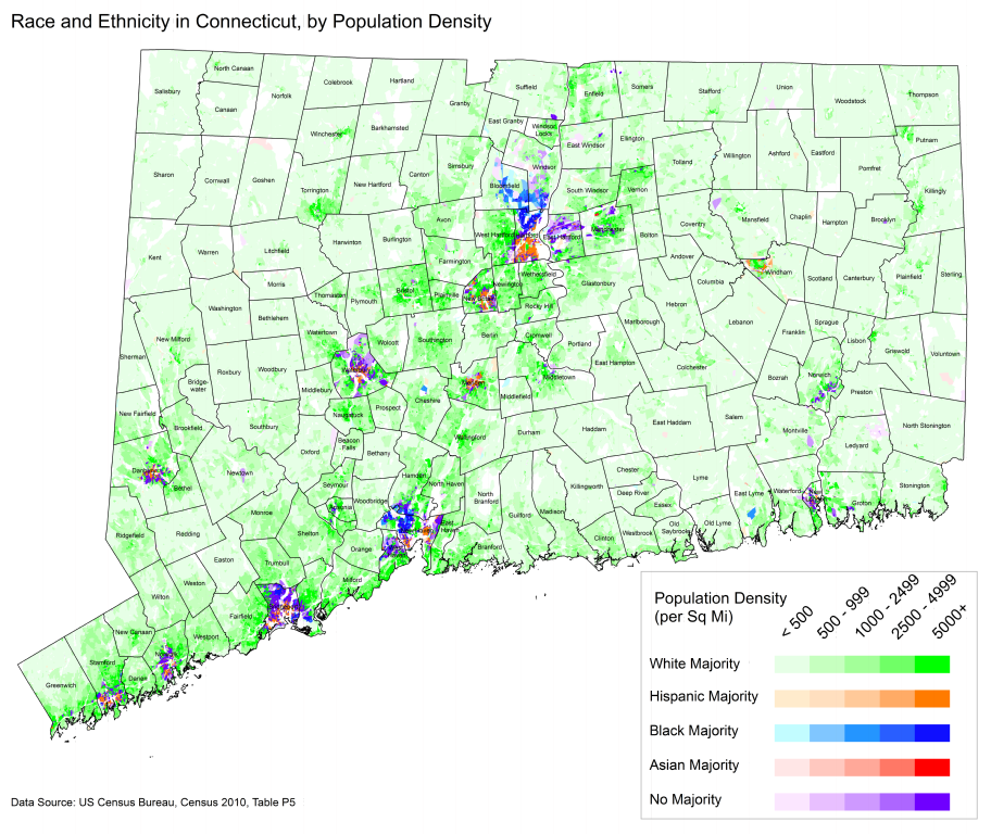
English: A map showing the majority racial or ethnic group in Connecticut by census block. Data comes from the 2010 US Census table P5. |
| Date | |
| Source | Using ArcGIS and census data |
| Author | Pgalag87 |
Licensing
I, the copyright holder of this work, hereby publish it under the following licenses:

|
Permission is granted to copy, distribute and/or modify this document under the terms of the GNU Free Documentation License, Version 1.2 or any later version published by the Free Software Foundation; with no Invariant Sections, no Front-Cover Texts, and no Back-Cover Texts. A copy of the license is included in the section entitled GNU Free Documentation License. |
This file is licensed under the Creative Commons Attribution-Share Alike 3.0 Unported license.
- You are free:
- to share – to copy, distribute and transmit the work
- to remix – to adapt the work
- Under the following conditions:
- attribution – You must give appropriate credit, provide a link to the license, and indicate if changes were made. You may do so in any reasonable manner, but not in any way that suggests the licensor endorses you or your use.
- share alike – If you remix, transform, or build upon the material, you must distribute your contributions under the same or compatible license as the original.
You may select the license of your choice.
File history
Click on a date/time to view the file as it appeared at that time.
| Date/Time | Thumbnail | Dimensions | User | Comment | |
|---|---|---|---|---|---|
| current | 23:53, 2 June 2014 | | 10,367 × 8,732 (2.82 MB) | JeffyP | I'm here to make the world a little bit smaller ☺ Also, brought back the higher-res version, and trimmed the borders. No charge today! |
| 20:54, 29 January 2013 |  | 5,500 × 4,250 (1.34 MB) | Pgalag87~commonswiki | {{subst:Upload marker added by en.wp UW}} {{Information |Description = {{en|A map showing the majority racial or ethnic group in Connecticut by census block. Data comes from the 2010 US Census table P5.}} |Source = Using ArcGIS and census data |Date = ... | |
| 20:53, 29 January 2013 |  | 6,600 × 5,100 (1.66 MB) | Pgalag87~commonswiki | {{subst:Upload marker added by en.wp UW}} {{Information |Description = {{en|A map showing the majority racial or ethnic group in Connecticut by census block. Data comes from the 2010 US Census table P5.}} |Source = Using ArcGIS and census data |Date = ... | |
| 20:44, 29 January 2013 |  | 13,200 × 10,200 (4.03 MB) | Pgalag87~commonswiki | {{subst:Upload marker added by en.wp UW}} {{Information |Description = {{en|A map showing the majority racial or ethnic group in Connecticut by census block. Data comes from the 2010 US Census table P5.}} |Source = Using ArcGIS and census data |Date = ... |
File usage
No pages on the English Wikipedia use this file (pages on other projects are not listed).
Global file usage
The following other wikis use this file:
- Usage on ja.wikipedia.org
- Usage on uk.wikipedia.org