
File:A1 railway.png

Original file (1,596 × 1,204 pixels, file size: 319 KB, MIME type: image/png)
| This is a file from the Wikimedia Commons. Information from its description page there is shown below. Commons is a freely licensed media file repository. You can help. |
| Description |
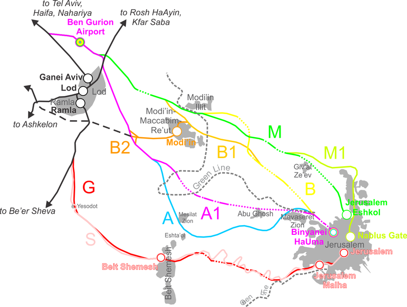
Map showing the plans for a Tel-Aviv--Jerusalem railway connection. Each alternative (S, G, A, A1, B, B1, B2, M, M1) is represented by a different color. Bold text and ciricles is for stations, while regular dark grey text is for city (12pt)/town (10pt)/village (8pt) names. Done with the help of a slew of other maps, not all of which had the same aspect ratio, etc. Therefore, try as I might, the map did not come out exactly to scale (probably) and has a few minor errors. The grey areas (built-up urban) are only shown for relevant localities, and are strictly demonstrative - they are generally not exact at all. Dotted lines denote tunnels. Bridges were not added, as I don't have the actual plans for these lines and the maps I have do not show bridges. |
| Date | |
| Source | Own work |
| Author | Ynhockey |

|
Permission is granted to copy, distribute and/or modify this document under the terms of the GNU Free Documentation License, Version 1.2 or any later version published by the Free Software Foundation; with no Invariant Sections, no Front-Cover Texts, and no Back-Cover Texts. A copy of the license is included in the section entitled GNU Free Documentation License. |
| This file is licensed under the Creative Commons Attribution-Share Alike 3.0 Unported license. | ||
| ||
| This licensing tag was added to this file as part of the GFDL licensing update. |
File history
Click on a date/time to view the file as it appeared at that time.
| Date/Time | Thumbnail | Dimensions | User | Comment | |
|---|---|---|---|---|---|
| current | 10:44, 2 May 2016 | | 1,596 × 1,204 (319 KB) | Ynhockey | Small clarifications in accordance with article text |
| 17:26, 24 April 2008 |  | 1,600 × 1,206 (305 KB) | Ynhockey | {{Information |Description=Map showing the plans for a Tel-Aviv--Jerusalem railway connection. Each plan (S, G, A, A1, B, B1, B2, M, M1) is represented by a different color. Bold text and ciricles is for stations, while regular dark grey text is for city |
File usage
Global file usage
The following other wikis use this file:
- Usage on ar.wikipedia.org
- Usage on de.wikipedia.org
- Usage on fr.wikipedia.org
- Usage on he.wikipedia.org
- Usage on ko.wikipedia.org
- Usage on nl.wikivoyage.org
- Usage on ru.wikipedia.org
- Usage on tr.wikipedia.org
- Usage on zh.wikipedia.org