
File:50nc ex leg copy.jpg

Size of this preview: 497 × 599 pixels. Other resolutions: 199 × 240 pixels | 510 × 615 pixels.
Original file (510 × 615 pixels, file size: 177 KB, MIME type: image/jpeg)
| This is a file from the Wikimedia Commons. Information from its description page there is shown below. Commons is a freely licensed media file repository. You can help. |
Summary
| Description |
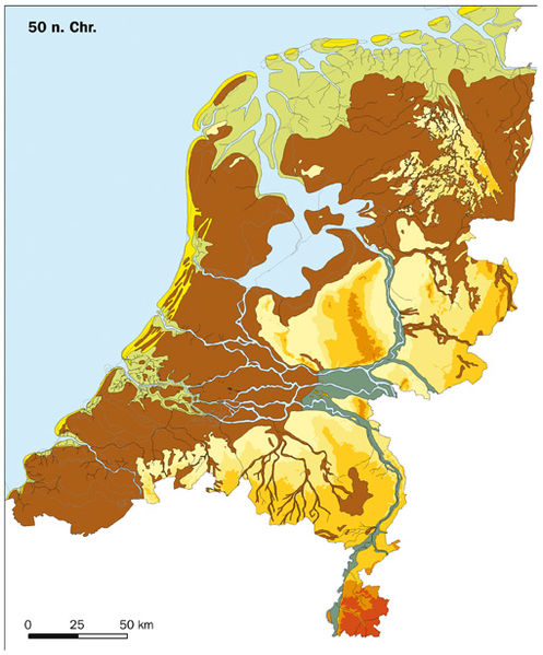
English: Palaeogeography of the Netherlands 50 AD
Dune and Beach ridge
Bogs, peat marshes, floodplain silt areas and basins of large rivers (including old river courses and riverbank breaches which have filled up with silt or peat)
Valley of large rivers (not covered with peat)
River dune (Pleistocene dunes)
Pleistocene landscape (> -6 m relative to NAP)
Pleistocene landscape ( -6 m - 0 m)
Pleistocene landscape ( 0 m - 10 m)
Pleistocene landscape( 10 m - 20 m)
Pleistocene landscape ( 20 m - 50 m)
Pleistocene landscape ( 50 m - 100 m)
Pleistocene landscape ( 100 m - 200 m)
Nederlands: Paleogeografie van Nederland rond 50 AD
Dal van de grote rivieren (niet overveend)
Rivierduinen (donken)
Pleistoceen landschap (> -6 m t.o.v. NAP)
Pleistoceen landschap ( -6 m - 0 m)
Pleistoceen] landschap( 0 m - 10 m)
Pleistoceen landschap ( 10 m - 20 m)
Pleistoceen landschap ( 20 m - 50 m)
Pleistoceen landschap ( 50 m - 100 m)
Pleistoceen landschap ( 100 m - 200 m)
Français : Paléogéographie des Pays-Bas vers l'an 50 de notre ère
Tourbières, bassins des grandes rivières et lit majeur (y compris les anciens cours d'eau et les brèches dans les berges qui se sont remplies de limon ou de tourbe.)
Vallée des grandes rivières (non recouvert de tourbe)
Dunes fluviales
Paysage pléistocène (> -6 m par rapport au NAP)
Paysage pléistocène ( -6 m - 0 m)
Paysage pléistocène ( 0 m - 10 m)
Paysage pléistocène ( 10 m - 20 m)
Paysage pléistocène ( 20 m - 50 m)
Paysage pléistocène ( 50 m - 100 m)
Paysage pléistocène ( 100 m - 200 m)
|
| Date | |
| Source | RACM & TNO. Developed for the Nationale Onderzoeksagenda Archeologie www.noaa.nl |
| Author | RACM & TNO |
| Permission (Reusing this file) |
Nederlands: Geachte heer Klein,
U heeft gevraagd om het gebruik van de nieuwe paleogeografische kaarten van Nederland voor Wikipedia. Namens de RACM, rechthebende op de afbeeldingen, sta ik u toe deze afbeeldingen te gebruiken onder de GFDL licentie. Als bronvermelding bij de afbeelding moet vermeld worden: "RACM & TNO. Ontwikkeld voor de Nationale Onderzoeksagenda Archeologie www.noaa.nl" (of de Engelse vertaling hiervan) Ik hoop u hiermee voldoende te hebben geïnformeerd. Met vriendelijke groet, Margje Vermeulen |
Licensing

|
Permission is granted to copy, distribute and/or modify this document under the terms of the GNU Free Documentation License, Version 1.2 or any later version published by the Free Software Foundation; with no Invariant Sections, no Front-Cover Texts, and no Back-Cover Texts. A copy of the license is included in the section entitled GNU Free Documentation License. |
| This file is licensed under the Creative Commons Attribution-Share Alike 3.0 Unported license. | ||
| ||
| This licensing tag was added to this file as part of the GFDL licensing update. |
File history
Click on a date/time to view the file as it appeared at that time.
| Date/Time | Thumbnail | Dimensions | User | Comment | |
|---|---|---|---|---|---|
| current | 11:57, 12 July 2007 | | 510 × 615 (177 KB) | BoH | {{legend|#fff15d|Strandwallen en duinen}} {{legend|#d2d500|Getijdengebied (zandwadden, slikken en kwelders)}} {{legend|#b56c03|Veenmoerassen en komgronden grote rivieren (inclusief verlande stroomgordels/crevassen)}} {{legend|#a1aa95|Dal van de grote rivi |
File usage
The following pages on the English Wikipedia use this file (pages on other projects are not listed):
Global file usage
The following other wikis use this file:
- Usage on ar.wikipedia.org
- Usage on ast.wikipedia.org
- Usage on ca.wikipedia.org
- Usage on cy.wikipedia.org
- Usage on da.wikipedia.org
- Usage on de.wikipedia.org
- Usage on et.wikipedia.org
- Usage on fi.wikipedia.org
- Usage on fr.wikipedia.org
- Lac Flevo
- Maîtrise des eaux aux Pays-Bas
- Discussion:Maîtrise des eaux aux Pays-Bas
- Wikipédia:Le saviez-vous ?/Archives/2015
- Wikipédia:Statistiques des anecdotes de la page d'accueil/Visibilité des anecdotes (2015)
- Wikipédia:Statistiques des anecdotes de la page d'accueil/Visibilité des anecdotes (2015)/2015 08
- Utilisateur:GhosterBot/Log/Archives/2015/août
- Usage on fy.wikipedia.org
- Usage on hi.wikipedia.org
- Usage on id.wikipedia.org
- Usage on it.wikipedia.org
- Usage on ja.wikipedia.org
- Usage on ko.wikipedia.org
- Usage on la.wikipedia.org
- Usage on nl.wikipedia.org
- Geschiedenis van Nederland
- Romeinen in Nederland
- 50
- Overleg:Drouwenerveen
- Geschiedenis van West-Friesland
- Geschiedenis van de Nederlanden in de Middeleeuwen
- Ontstaan van de Nederlandse ondergrond
- Istvaeones
- Maritieme geschiedenis van de Nederlanden: van de prehistorie tot 1585
- Gebruiker:Evil berry/Tijdlijn België
- Geschiedenis van Belfeld
- Overleg:Istvaeones
- Tijdlijn van de Lage Landen (Romeinse tijd)
- Usage on no.wikipedia.org
- Usage on pt.wikipedia.org
- Usage on ru.wikipedia.org
- Usage on sr.wikipedia.org
- Usage on uk.wikipedia.org
- Usage on zh.wikipedia.org