
File:400 Germania I II Belgica I II.png
No higher resolution available.
400_Germania_I_II_Belgica_I_II.png (522 × 461 pixels, file size: 263 KB, MIME type: image/png)
| This is a file from the Wikimedia Commons. Information from its description page there is shown below. Commons is a freely licensed media file repository. You can help. |
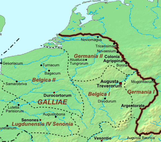
Summary
| Description |
Nederlands: Lageresolutiekaart in plate-carreprojectie met hedendaagse kustlijn van de Romeinse provincies Germania Prima (Germania I), Germania Secunda (Germania II), Belgica Prima (Belgica I) en Belgica Secunda (Belgica II) rond 400 n.Chr. Deutsch: Die römische Provinzen Germania Prima (Germania I), Germania Secunda (Germania II), Belgica Prima (Belgica I) und Belgica Secunda (Belgica II) um 400 n. Chr. English: Low resolution map in plate caree projection with modern coastline of the Roman provinces of Germania Prima (Germania I), Germania Secunda (Germania II), Belgica Prima (Belgica I) and Belgica Secunda (Belgica II) around 400 AD. Français : Les provinces de Germania Prima (Germania I), Germania Secunda (Germania II), Belgica Prima (Belgica I) et Belgica Secunda (Belgica II) vers 400 ap. J.-C.. |
| Date | |
| Source | Excerpt from Map of the Roman Empire |
| Author | User:Cplakidas |
Licensing
This file is licensed under the Creative Commons Attribution 3.0 Unported license.
- You are free:
- to share – to copy, distribute and transmit the work
- to remix – to adapt the work
- Under the following conditions:
- attribution – You must give appropriate credit, provide a link to the license, and indicate if changes were made. You may do so in any reasonable manner, but not in any way that suggests the licensor endorses you or your use.
File history
Click on a date/time to view the file as it appeared at that time.
| Date/Time | Thumbnail | Dimensions | User | Comment | |
|---|---|---|---|---|---|
| current | 22:50, 19 January 2012 | | 522 × 461 (263 KB) | Nederlandse Leeuw |
File usage
The following pages on the English Wikipedia use this file (pages on other projects are not listed):
Global file usage
The following other wikis use this file:
- Usage on de.wikipedia.org
- Usage on et.wikipedia.org
- Usage on fr.wikipedia.org
- Usage on nl.wikipedia.org
- Usage on wa.wikipedia.org
- Usage on www.wikidata.org