
File:3 stages of geological development at Croft Quarry. - geograph.org.uk - 1136369.jpg
No higher resolution available.
3_stages_of_geological_development_at_Croft_Quarry._-_geograph.org.uk_-_1136369.jpg (640 × 458 pixels, file size: 215 KB, MIME type: image/jpeg)
| This is a file from the Wikimedia Commons. Information from its description page there is shown below. Commons is a freely licensed media file repository. You can help. |
Summary
| Description |
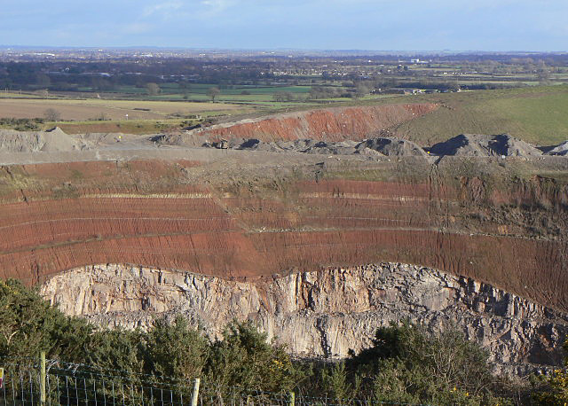
English: 3 stages of geological development at Croft Quarry.. The rock being quarried is granite, so the lowest levels are relatively early igneous formations. The slightly redder patch just to the right of the strong near-vertical shadow just right of centre shows tightly curved strata (not clearly visible at this scale) indicative of a rising stream of magma.
The second stage is the clear evidence of glacial erosion of the granite shown by the smoothly curved boundary between the granite and the overlying sedimentary formations. A noticeable feature of the latter is the way they have been deposited preferentially into the hollows of the underlying granite so that the successive layers show less and less curvature, ending with an essentially horizontal top layer. The sedimentary deposits are mainly red mudstone with some thin intermediate layers of lighter coloured deposits. A more detailed view of part of this formation can be seen in 1136362. |
| Date | |
| Source | From geograph.org.uk |
| Author | Alan Murray-Rust |
| Attribution (required by the license) | Alan Murray-Rust / 3 stages of geological development at Croft Quarry. / |
| Camera location | | View this and other nearby images on: OpenStreetMap |
|---|
_heading:67.00&language=en)
| Object location | | View this and other nearby images on: OpenStreetMap |
|---|
_heading:67.00&language=en)
Licensing

|
This image was taken from the Geograph project collection. See this photograph's page on the Geograph website for the photographer's contact details. The copyright on this image is owned by Alan Murray-Rust and is licensed for reuse under the Creative Commons Attribution-ShareAlike 2.0 license.
|
This file is licensed under the Creative Commons Attribution-Share Alike 2.0 Generic license.
Attribution: Alan Murray-Rust
- You are free:
- to share – to copy, distribute and transmit the work
- to remix – to adapt the work
- Under the following conditions:
- attribution – You must give appropriate credit, provide a link to the license, and indicate if changes were made. You may do so in any reasonable manner, but not in any way that suggests the licensor endorses you or your use.
- share alike – If you remix, transform, or build upon the material, you must distribute your contributions under the same or compatible license as the original.
File history
Click on a date/time to view the file as it appeared at that time.
| Date/Time | Thumbnail | Dimensions | User | Comment | |
|---|---|---|---|---|---|
| current | 03:01, 25 February 2011 | | 640 × 458 (215 KB) | GeographBot | == {{int:filedesc}} == {{Information |description={{en|1=3 stages of geological development at Croft Quarry. The rock being quarried is granite, so the lowest levels are relatively early igneous formations. The slightly redder patch just to the right of t |
File usage
The following pages on the English Wikipedia use this file (pages on other projects are not listed):