
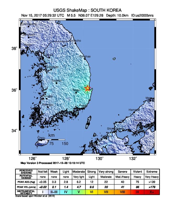
File:2017 Pohang earthquake intensity map.jpg
Size of this preview: 511 × 600 pixels. Other resolutions: 204 × 240 pixels | 612 × 718 pixels.
Original file (612 × 718 pixels, file size: 109 KB, MIME type: image/jpeg)
| This is a file from the Wikimedia Commons. Information from its description page there is shown below. Commons is a freely licensed media file repository. You can help. |
Summary
| Description |
English: Shakemap for the earthquake |
| Date | |
| Source | https://earthquake.usgs.gov/earthquakes/eventpage/us2000bnrs#shakemap |
| Author | USGS |
Licensing
This image is in the public domain in the United States because it only contains materials that originally came from the United States Geological Survey, an agency of the United States Department of the Interior. For more information, see the official USGS copyright policy.
|
File history
Click on a date/time to view the file as it appeared at that time.
| Date/Time | Thumbnail | Dimensions | User | Comment | |
|---|---|---|---|---|---|
| current | 20:53, 18 March 2018 | | 612 × 718 (109 KB) | Alex of Canada | User created page with UploadWizard |
File usage
The following pages on the English Wikipedia use this file (pages on other projects are not listed):
Global file usage
The following other wikis use this file:
- Usage on es.wikipedia.org
- Usage on fr.wikipedia.org
- Usage on ko.wikipedia.org
- Usage on zh.wikipedia.org