
File:2015UKElectionMap.svg

Size of this PNG preview of this SVG file: 720 × 599 pixels. Other resolutions: 288 × 240 pixels | 577 × 480 pixels | 923 × 768 pixels | 1,230 × 1,024 pixels | 2,460 × 2,048 pixels | 1,248 × 1,039 pixels.
Original file (SVG file, nominally 1,248 × 1,039 pixels, file size: 5.18 MB)
| This is a file from the Wikimedia Commons. Information from its description page there is shown below. Commons is a freely licensed media file repository. You can help. |
Summary
| Description |
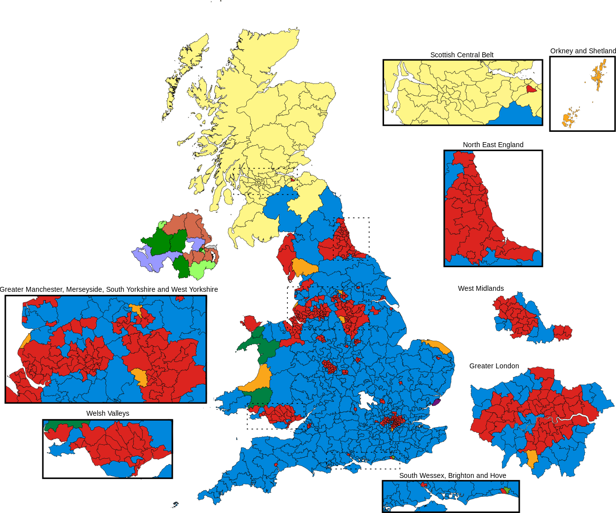
English: Results of the 2015 general election in the United Kingdom. Ultimately based upon data from the Boundary Commission. Colours are as below.
Deutsch: Ergebnis der Unterhauswahl vom 7. Mai 2015. Parteifarben s. o.. |
| Date | |
| Source |
This file was derived from: 2010UKElectionMap.svg |
| Author | Brythones, recoloured by Cryptographic.2014 |
| Permission (Reusing this file) |
I, the copyright holder of this work, hereby publish it under the following license: This file is licensed under the Creative Commons Attribution-Share Alike 4.0 International license.
|
File history
Click on a date/time to view the file as it appeared at that time.
| Date/Time | Thumbnail | Dimensions | User | Comment | |
|---|---|---|---|---|---|
| current | 19:46, 31 December 2019 | | 1,248 × 1,039 (5.18 MB) | BippyTheGuy | Labour held Ashfield. |
| 07:17, 3 November 2017 |  | 1,248 × 1,039 (5.33 MB) | Into oblivion | changed SNP colour to match official party colour | |
| 14:23, 16 May 2017 |  | 1,248 × 1,039 (5.33 MB) | Renamed user OCfxJKu7j2 | Consistent with 2017 map | |
| 16:19, 7 May 2017 |  | 1,020 × 996 (5.05 MB) | RaviC | Orkney and Shetland to map from OrkneyShetlandConstituency.svg | |
| 01:25, 23 December 2016 |  | 1,020 × 996 (5.01 MB) | Renamed user OCfxJKu7j2 | Fixed text | |
| 11:59, 31 August 2015 |  | 1,020 × 996 (5.01 MB) | Aight 2009 | fixed colors for parties, my fault in previous edit, cons were fine | |
| 09:07, 31 August 2015 |  | 1,020 × 996 (5.05 MB) | Renamed user OCfxJKu7j2 | Reverted to version as of 08:52, 9 May 2015 former party colours are consistent with those used across wiki. | |
| 15:11, 30 August 2015 |  | 1,020 × 996 (5.01 MB) | Aight 2009 | improved colors with party colors template | |
| 08:52, 9 May 2015 |  | 1,020 × 996 (5.05 MB) | Renamed user OCfxJKu7j2 | Moving 2015UKElectionMap_-_Ilford_&_Clwyd_fixed,_recoloured.svg to 2015UKElectionMap.svg to avoid meaningless file name. | |
| 15:06, 8 May 2015 |  | 1,020 × 996 (7.75 MB) | Renamed user OCfxJKu7j2 | User created page with UploadWizard |
File usage
The following pages on the English Wikipedia use this file (pages on other projects are not listed):
- 2015 United Kingdom general election
- List of MPs elected in the 2015 United Kingdom general election
- Talk:2015 United Kingdom general election/Archive 5
- Talk:2015 United Kingdom general election/Archive 6
- Talk:2015 United Kingdom general election/TIE and TILE
- User:Aussie Kaiser/sandbox
- User:Britannia237/sandbox
- User:Byzantium Purple/sandbox/UK
- User:Haraken3/sandbox
- User:Ivan3999/sandbox
- User:Nallerton/sandbox
- User:Quantum Burrito/test new template
- Wikipedia:Reference desk/Archives/Humanities/2015 May 9
- Wikipedia:Reference desk/Archives/Humanities/2017 June 9
- Wikipedia:Top 25 Report/May 3 to 9, 2015
- Wikipedia talk:WikiProject Politics of the United Kingdom/Archive 6
Global file usage
The following other wikis use this file:
- Usage on af.wikipedia.org
- Usage on cs.wikipedia.org
- Usage on da.wikipedia.org
- Usage on de.wikipedia.org
- Usage on el.wikipedia.org
- Usage on en.wikinews.org
- Usage on es.wikipedia.org
- Usage on es.wikinews.org
- Usage on fa.wikipedia.org
- Usage on fi.wikipedia.org
- Usage on fo.wikipedia.org
- Usage on fr.wikipedia.org
- Usage on he.wikipedia.org
- Usage on hu.wikipedia.org
- Usage on it.wikipedia.org
- Usage on ja.wikipedia.org
- Usage on ko.wikipedia.org
- Usage on kw.wikipedia.org
- Usage on ms.wikipedia.org
- Usage on nl.wikipedia.org
- Usage on no.wikipedia.org
- Usage on pl.wikipedia.org
- Usage on pt.wikipedia.org
- Usage on pt.wikinews.org
- Usage on ru.wikipedia.org
- Usage on sco.wikipedia.org
- Usage on simple.wikipedia.org
- Usage on sr.wikipedia.org
- Usage on ta.wikipedia.org
- Usage on th.wikipedia.org
- Usage on tr.wikipedia.org
- Usage on vi.wikipedia.org
- Usage on www.wikidata.org
- Usage on zh-yue.wikipedia.org
- Usage on zh.wikipedia.org