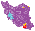
File:2013 Presidential Election map-Iran.svg

Size of this PNG preview of this SVG file: 672 × 600 pixels. Other resolutions: 269 × 240 pixels | 538 × 480 pixels | 861 × 768 pixels | 1,147 × 1,024 pixels | 2,295 × 2,048 pixels | 1,200 × 1,071 pixels.
Original file (SVG file, nominally 1,200 × 1,071 pixels, file size: 486 KB)
File history
Click on a date/time to view the file as it appeared at that time.
| Date/Time | Thumbnail | Dimensions | User | Comment | |
|---|---|---|---|---|---|
| current | 14:29, 17 November 2019 |  | 1,200 × 1,071 (486 KB) | Shyamal | Remove metadata block, should detect as pure SVG now |
| 09:33, 3 October 2019 |  | 1,200 × 1,071 (486 KB) | NikNaks | First draft of true SVG, based on File:Iranian_presidential_election,_2017.svg | |
| 19:20, 22 June 2013 |  | 1,281 × 878 (104 KB) | BasilLeaf | آخرین بروزرسانی | |
| 08:26, 17 June 2013 |  | 1,281 × 878 (114 KB) | BasilLeaf | بروزرسانی شهرستان نطنز بروزرسانی شهرستان آران و بیدگل بروزرسانی شهرستان اردستان | |
| 07:50, 17 June 2013 |  | 1,325 × 950 (108 KB) | Garam | Fix; (...) | |
| 07:14, 17 June 2013 |  | 1,281 × 878 (111 KB) | BasilLeaf | بروززسانی شهرستان ماکو بروزرسانی شهرستان شوط بروزرسانی شهرستان شوشتر بروزرسانی شهرستان لالی بروزرسانی شهرستان رباط کریم بروزرسانی شهرس... | |
| 02:27, 17 June 2013 |  | 1,281 × 878 (88 KB) | Garam | Category:Iranian presidential election, 2013 Category:Iranian election map |
File usage
The following pages on the English Wikipedia use this file (pages on other projects are not listed):
Global file usage
The following other wikis use this file:
- Usage on ar.wikipedia.org
- Usage on de.wikipedia.org
- Usage on es.wikipedia.org
- Usage on fa.wikipedia.org
- Usage on fi.wikipedia.org
- Usage on fr.wikipedia.org
- Usage on id.wikipedia.org
- Usage on it.wikipedia.org
- Usage on ja.wikipedia.org
- Usage on ko.wikipedia.org
- Usage on sv.wikipedia.org
- Usage on tr.wikipedia.org
- Usage on zh-yue.wikipedia.org
- Usage on zh.wikipedia.org


