
File:2012 United States presidential election results map by county.svg

Size of this PNG preview of this SVG file: 556 × 352 pixels. Other resolutions: 320 × 203 pixels | 640 × 405 pixels | 1,024 × 648 pixels | 1,280 × 810 pixels | 2,560 × 1,621 pixels.
Original file (SVG file, nominally 556 × 352 pixels, file size: 1.1 MB)
| This is a file from the Wikimedia Commons. Information from its description page there is shown below. Commons is a freely licensed media file repository. You can help. |
Summary
| Description |
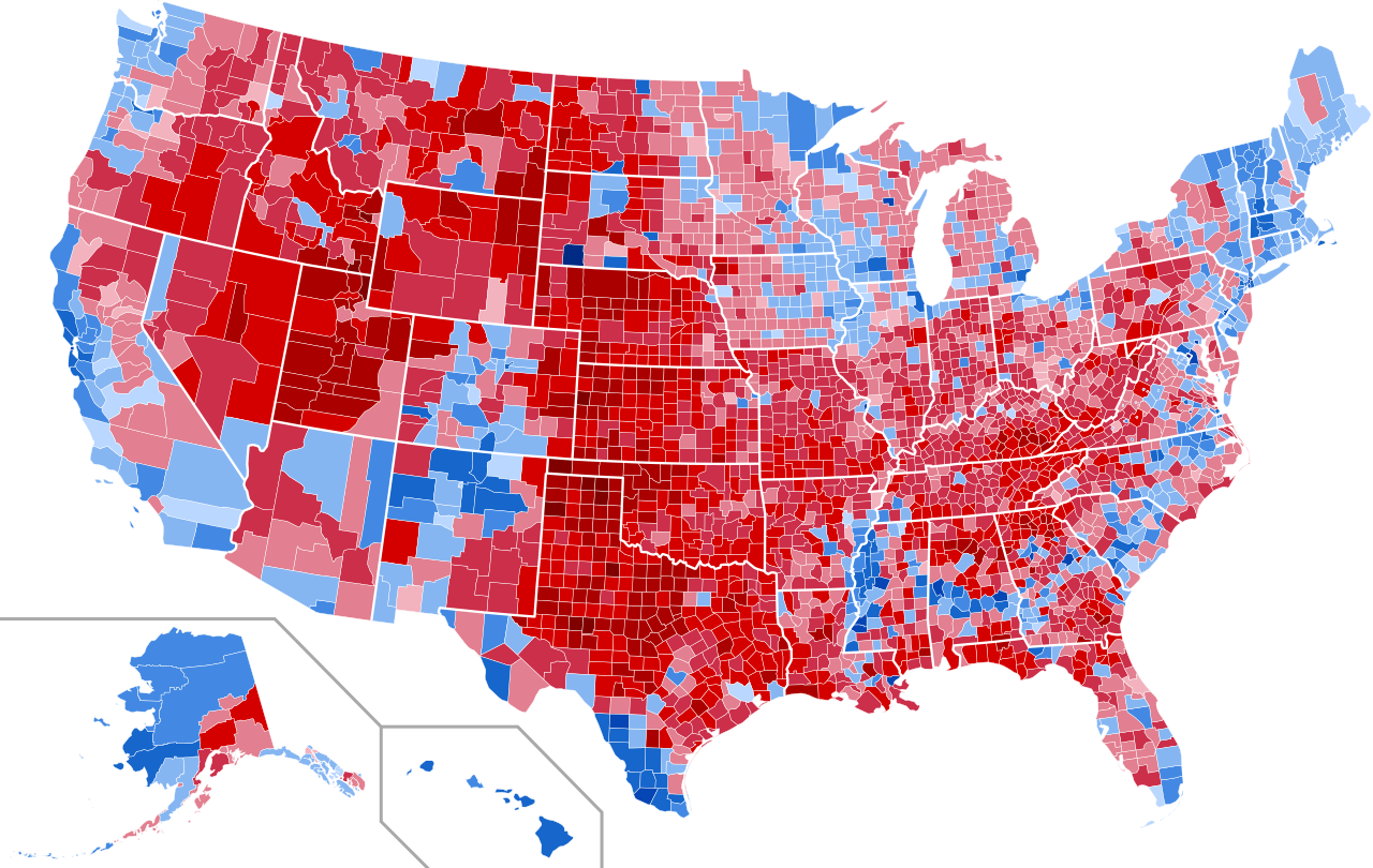
English: Results of the United States presidential election, 2012
Obama—>90%
Obama—80-90%
Obama—70-80%
Obama—60-70%
Obama—50-60%
Obama—<50%
Romney—<50%
Romney—50-60%
Romney—60-70%
Romney—70-80%
Romney—80-90%
Romney—>90% |
| Date | |
| Source | Own work |
| Author | Inqvisitor |
Licensing
I, the copyright holder of this work, hereby publish it under the following license:
This file is licensed under the Creative Commons Attribution-Share Alike 3.0 Unported license.
- You are free:
- to share – to copy, distribute and transmit the work
- to remix – to adapt the work
- Under the following conditions:
- attribution – You must give appropriate credit, provide a link to the license, and indicate if changes were made. You may do so in any reasonable manner, but not in any way that suggests the licensor endorses you or your use.
- share alike – If you remix, transform, or build upon the material, you must distribute your contributions under the same or compatible license as the original.
File history
Click on a date/time to view the file as it appeared at that time.
| Date/Time | Thumbnail | Dimensions | User | Comment | |
|---|---|---|---|---|---|
| current | 23:05, 3 March 2023 | | 556 × 352 (1.1 MB) | Gordfather69 | Line width |
| 04:09, 22 June 2021 |  | 556 × 352 (878 KB) | TylerKutschbach | Fixed some results | |
| 19:43, 11 August 2013 |  | 555 × 352 (1.5 MB) | Inqvisitor | Improve alignment of Alaska Panhandle | |
| 23:03, 4 August 2013 |  | 555 × 352 (1.5 MB) | Inqvisitor | Improve visibility of NYC area | |
| 22:19, 10 May 2013 |  | 555 × 352 (1.5 MB) | Inqvisitor | TN updated | |
| 18:21, 2 May 2013 |  | 555 × 352 (1.5 MB) | Inqvisitor | Improve light shade visibility | |
| 04:58, 15 March 2013 |  | 555 × 352 (1.5 MB) | Inqvisitor | Updates | |
| 05:40, 6 March 2013 |  | 555 × 352 (1.5 MB) | Inqvisitor | Bristol, RI change | |
| 21:43, 25 February 2013 |  | 555 × 352 (1.5 MB) | Inqvisitor | Salem County, NJ update | |
| 21:27, 18 January 2013 |  | 555 × 352 (1.5 MB) | Inqvisitor | Alaska again...fixing Anchorage |
File usage
The following pages on the English Wikipedia use this file (pages on other projects are not listed):
Global file usage
The following other wikis use this file:
- Usage on es.wikipedia.org