
File:2008 Democratic Primaries Pledged Delegates by Region.gif
No higher resolution available.
2008_Democratic_Primaries_Pledged_Delegates_by_Region.gif (700 × 534 pixels, file size: 39 KB, MIME type: image/gif)
| This is a file from the Wikimedia Commons. Information from its description page there is shown below. Commons is a freely licensed media file repository. You can help. |
Summary
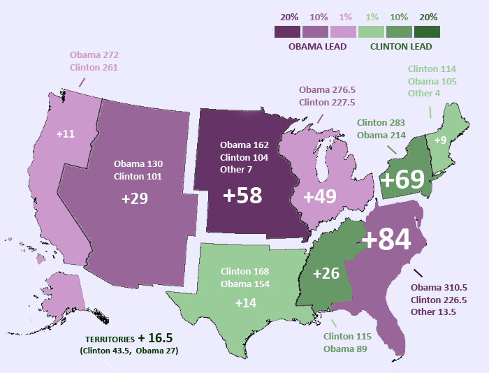
| Description | 2008 United States Democratic Primaries, Pledged Delegates by Region. Regions are outlined according to United States census categories. The darkest purple regions voted for Obama by the largest margins. The darkest green states vote for Clinton by the largest margins. NOTE: This map is intended to reflect "election results." It reflects delegate changes that occur in states where delegates are selected through multiple events (e.g. IA, TX) but not delegate changes that have occurred in other states where bound delegates have indicated an intention to vote otherwise at the convention (e.g. NH, MD). |
| Source | Own work |
| Author | Northwest-historian |
Licensing
| I, the copyright holder of this work, release this work into the public domain. This applies worldwide. In some countries this may not be legally possible; if so: I grant anyone the right to use this work for any purpose, without any conditions, unless such conditions are required by law. |
File history
Click on a date/time to view the file as it appeared at that time.
| Date/Time | Thumbnail | Dimensions | User | Comment | |
|---|---|---|---|---|---|
| current | 07:22, 4 June 2008 | | 700 × 534 (39 KB) | Northwest-historian | +MT, SD |
| 04:51, 2 June 2008 |  | 700 × 534 (40 KB) | Northwest-historian | Updated for PR. Fixed Pacific region (numbers were transposed). Fixed color in Alaska. | |
| 01:32, 1 June 2008 |  | 700 × 534 (40 KB) | Northwest-historian | updated for FL/MI | |
| 15:43, 24 May 2008 |  | 700 × 534 (35 KB) | TheHoosierState89 | minor color fix (small part of Alaska was green) | |
| 22:08, 23 May 2008 |  | 700 × 534 (40 KB) | Northwest-historian | fix | |
| 22:07, 23 May 2008 |  | 700 × 534 (40 KB) | Northwest-historian | fix | |
| 22:05, 23 May 2008 |  | 700 × 534 (40 KB) | Northwest-historian | update with KY + OR (fixed) | |
| 22:04, 23 May 2008 |  | 700 × 534 (40 KB) | Northwest-historian | Updated with OR and KY | |
| 21:29, 14 May 2008 |  | 700 × 534 (40 KB) | Northwest-historian | WV results | |
| 21:49, 9 May 2008 |  | 700 × 534 (41 KB) | Northwest-historian | Updated again. Map was missing WY results. |
File usage
The following pages on the English Wikipedia use this file (pages on other projects are not listed):
Global file usage
The following other wikis use this file:
- Usage on pt.wikipedia.org