
File:2000census- Black Residential Segregation.JPG
No higher resolution available.
2000census-_Black_Residential_Segregation.JPG (700 × 558 pixels, file size: 233 KB, MIME type: image/jpeg)
| This is a file from the Wikimedia Commons. Information from its description page there is shown below. Commons is a freely licensed media file repository. You can help. |
Summary
| Description |
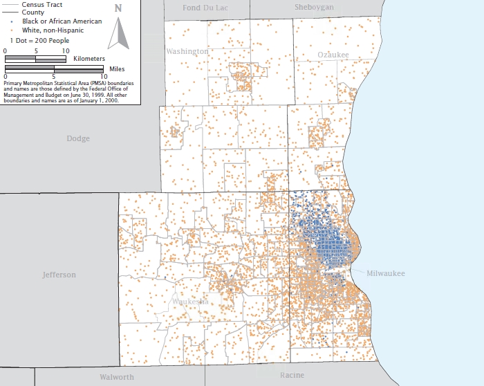
English: A map showing residential black segregation in the 2000 Census' most segregated American city, Milwaukee, Wisconsin. |
| Date | |
| Source | US Census Bureau (https://www.census.gov/hhes/www/housing/housing_patterns/pdf/Fig5-3.pdf) |
| Author | US Census Bureau, 2000 Census |
Licensing
This image or file is a work of a United States Census Bureau employee, taken or made as part of that person's official duties. As a work of the U.S. federal government, the image is in the public domain.
|
 |
File history
Click on a date/time to view the file as it appeared at that time.
| Date/Time | Thumbnail | Dimensions | User | Comment | |
|---|---|---|---|---|---|
| current | 05:07, 2 October 2009 | | 700 × 558 (233 KB) | Jim37hike | {{Information |Description={{en|1=A map showing residential black segregation in the 2000 Census' most segregated American city, Milwaukee, Wisconsin.}} |Source=US Census Bureau (http://www.census.gov/hhes/www/housing/housing_patterns/pdf/Fig5-3.pdf) |Aut |
File usage
The following pages on the English Wikipedia use this file (pages on other projects are not listed):
Global file usage
The following other wikis use this file:
- Usage on zh.wikipedia.org