
File:1947 Partition 1949 Armistice.jpg
Size of this preview: 336 × 599 pixels. Other resolutions: 134 × 240 pixels | 453 × 808 pixels.
Original file (453 × 808 pixels, file size: 64 KB, MIME type: image/jpeg)
| This is a file from the Wikimedia Commons. Information from its description page there is shown below. Commons is a freely licensed media file repository. You can help. |
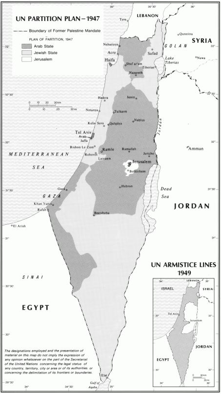
Summary
| Description |
English: 1947 Proposed Boundaries and 1949 demarcation lines, Jerusalem, Palestine question |
| Date | |
| Source | https://www.un.org/unispal/document/auto-insert-208958/ |
| Author | United Nations |
Licensing
This file is licensed under the Creative Commons Attribution-Share Alike 4.0 International license.
- You are free:
- to share – to copy, distribute and transmit the work
- to remix – to adapt the work
- Under the following conditions:
- attribution – You must give appropriate credit, provide a link to the license, and indicate if changes were made. You may do so in any reasonable manner, but not in any way that suggests the licensor endorses you or your use.
- share alike – If you remix, transform, or build upon the material, you must distribute your contributions under the same or compatible license as the original.
File history
Click on a date/time to view the file as it appeared at that time.
| Date/Time | Thumbnail | Dimensions | User | Comment | |
|---|---|---|---|---|---|
| current | 11:06, 21 April 2020 | | 453 × 808 (64 KB) | Selfstudier | Uploaded a work by United Nations from https://www.un.org/unispal/document/auto-insert-208958/ with UploadWizard |
File usage
No pages on the English Wikipedia use this file (pages on other projects are not listed).
Global file usage
The following other wikis use this file:
- Usage on oc.wiktionary.org
- Usage on pnb.wikipedia.org
- Usage on ur.wikipedia.org