
File:1912 United States House Map.png

Original file (1,514 × 975 pixels, file size: 97 KB, MIME type: image/png)
Summary[edit][edit]
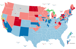
This is an adaption of a house map made by Jackson from Dave Leip's Atlas Form. This shows the United States house after the 1916 election. The only difference is that the seats are recolored for this election, the Texas, Washington, Oklahoma, Colorado, Michigan, Ohio, Alabama, Florida, West Virginia and Manhattan house maps are changed to be accurate to this year and some other very minor map shape changes including changes in Georgia and South Carolina. Under the license for this work you are free: to share - to copy, distribute and transmit the work and to remix - to adapt the work. Under the following conditions: attribution - You must give appropriate credit, provide a link to the license and indicate if changes were made. You may do so in any reasonable manner, but not in any way that suggests the licensor endorses you or your use. share alike - If you remix, transform or build upon that material, you must distribute your contributions under a similar or compatible license as the original.
Licensing[edit]
| This work is licensed under the Creative Commons Attribution-ShareAlike 3.0 License. |
File history
Click on a date/time to view the file as it appeared at that time.
| Date/Time | Thumbnail | Dimensions | User | Comment | |
|---|---|---|---|---|---|
| current | 13:13, 26 June 2021 | | 1,514 × 975 (97 KB) | GastonN'estPasBon (talk | contribs) |
You cannot overwrite this file.