
File:1907 Geological Survey Map of San Francisco after 1906 Earthquake - Geographicus - SanFrancisco-humphrey-1907.jpg
Original file (3,000 × 2,394 pixels, file size: 1.85 MB, MIME type: image/jpeg)
| This is a file from the Wikimedia Commons. Information from its description page there is shown below. Commons is a freely licensed media file repository. You can help. |
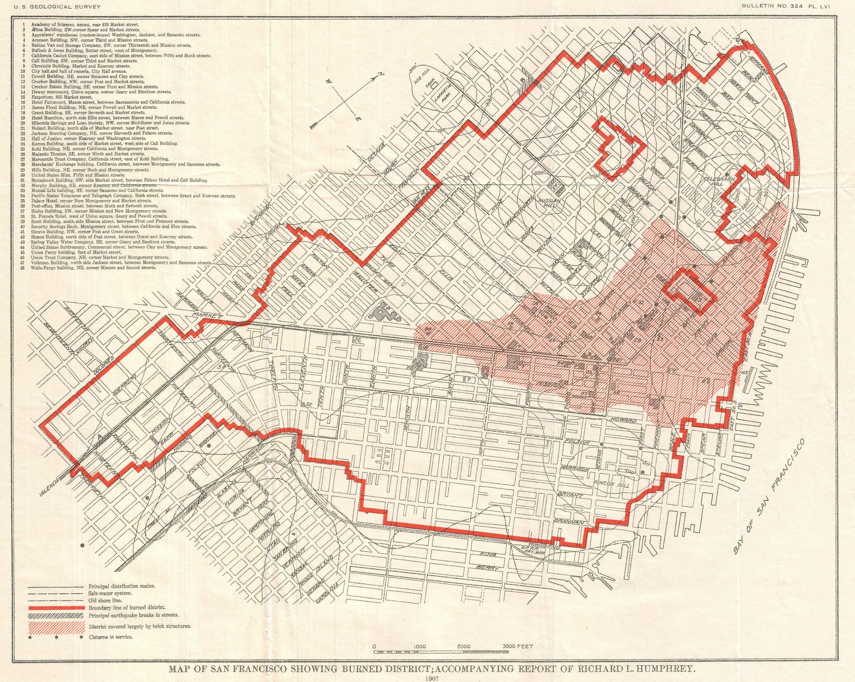
| Map of San Francisco Showing Burned District; Accompanying Report of Richard L. Humphrey. | ||||||
|---|---|---|---|---|---|---|
| Artist | ||||||
| Title |
Map of San Francisco Showing Burned District; Accompanying Report of Richard L. Humphrey. |
|||||
| Description |
English: An unusual map of San Francisco, California, dating to 1907. This map was published by the U.S. Geological Survey following the terrible San Francisco Earthquake and Fire of 1906. This natural disaster, comparable to the devastation wrought by Hurricane Katrina, is considered the largest is California History. This map highlights the developed parts of San Francisco most damaged by the fire in red ink. It also shows the region occupied primarily by brick buildings, streets, water conduits, some topographical features, earthquake damage to streets, and cisterns. Published in the U.S. Geological Survey's report on the San Francisco Earthquake and Fire, 1907. |
|||||
| Date | 1907 (dated) | |||||
| Dimensions | height: 11 in (27.9 cm); width: 13.7 in (34.9 cm) | |||||
| Accession number |
Geographicus link: SanFrancisco-humphrey-1907 |
|||||
| Source/Photographer |
Humphrey, R. L., The San Francisco Earthquake and Fire of April 18, 1906, U. S. Geological Survey, 1907.
|
|||||
| Permission (Reusing this file) |
|
|||||
File history
Click on a date/time to view the file as it appeared at that time.
| Date/Time | Thumbnail | Dimensions | User | Comment | |
|---|---|---|---|---|---|
| current | 18:58, 23 March 2011 | | 3,000 × 2,394 (1.85 MB) | BotMultichillT | {{subst:User:Multichill/Geographicus |link=http://www.geographicus.com/P/AntiqueMap/SanFrancisco-humphrey-1907 |product_name=1907 Geological Survey Map of San Francisco after 1906 Earthquake |map_title=Map of San Francisco Showing Burned District; Accompa |
File usage
Global file usage
The following other wikis use this file:
- Usage on de.wikipedia.org
- Usage on el.wikipedia.org
- Usage on ms.wikipedia.org