File:1902 Andes Boundary Case.svg

Page contents not supported in other languages.
This is a file from the Wikimedia Commons
From Wikipedia, the free encyclopedia

Original file(SVG file, nominally 1,430 × 1,720 pixels, file size: 1.47 MB)

Summary

Description
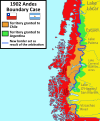
English: This map shows the disputed territories between Chile and Argentina between 1881 and 1902 and its resolution with the arbitration award of the King of the United Kingdom Edward VII .
Español: Este mapa muestra los territorios en disputa entre Chile y Argentina entre los años 1881 y 1902 y su resolución con el Laudo arbitral del rey Eduardo VII del Reino Unido.
Date
Source

Own work

Based on: [1] [2][3][4]

Coastline extracted from: File:Chile location map.svg by NordNordWest
Author Janitoalevic
Coastline extracted from: File:Chile location map.svg by NordNordWest
Other versions

Licensing

I, the copyright holder of this work, hereby publish it under the following license:
w:en:Creative Commons
attribution share alike
This file is licensed under the Creative Commons Attribution-Share Alike 3.0 Unported license.
You are free:
  • to share – to copy, distribute and transmit the work
  • to remix – to adapt the work
Under the following conditions:
  • attribution – You must give appropriate credit, provide a link to the license, and indicate if changes were made. You may do so in any reasonable manner, but not in any way that suggests the licensor endorses you or your use.
  • share alike – If you remix, transform, or build upon the material, you must distribute your contributions under the same or compatible license as the original.

Captions

Add a one-line explanation of what this file represents

Items portrayed in this file

depicts

3 November 2018

image/svg+xml

5c7f936ddf568ced4a847c67c810bfc3a07fab3c

1,608,769 byte

1,720 pixel

1,430 pixel

File history

Click on a date/time to view the file as it appeared at that time.

Date/TimeThumbnailDimensionsUserComment
current16:59, 23 October 2023Thumbnail for version as of 16:59, 23 October 20231,430 × 1,720 (1.47 MB)JanitoalevicBorders
00:27, 29 December 2022Thumbnail for version as of 00:27, 29 December 20221,430 × 1,720 (1.53 MB)JanitoalevicSouthern Patagonian Ice Field
20:02, 12 July 2020Thumbnail for version as of 20:02, 12 July 20201,430 × 1,720 (1.46 MB)JanitoalevicRemoved duplicated text.
00:10, 4 November 2018Thumbnail for version as of 00:10, 4 November 20181,430 × 1,720 (1.47 MB)JanitoalevicText
00:09, 4 November 2018Thumbnail for version as of 00:09, 4 November 20181,430 × 1,720 (1.15 MB)JanitoalevicUser created page with UploadWizard
The following pages on the English Wikipedia use this file (pages on other projects are not listed):

Metadata