
File:1890 Bacon Traveler's Pocket Map of London, England - Geographicus - London-bacon-1890.jpg

Size of this preview: 782 × 599 pixels. Other resolutions: 313 × 240 pixels | 627 × 480 pixels | 1,002 × 768 pixels | 1,280 × 981 pixels | 2,560 × 1,962 pixels | 6,000 × 4,598 pixels.
Original file (6,000 × 4,598 pixels, file size: 11.4 MB, MIME type: image/jpeg)
| This is a file from the Wikimedia Commons. Information from its description page there is shown below. Commons is a freely licensed media file repository. You can help. |
| George Washington Bacon: Bacon's New Map of London Divided into Half Mile Squares & Circles.
( |
|||||||||||||||||
|---|---|---|---|---|---|---|---|---|---|---|---|---|---|---|---|---|---|
| Artist |
|
||||||||||||||||
| Title |
Bacon's New Map of London Divided into Half Mile Squares & Circles. |
||||||||||||||||
| Description |
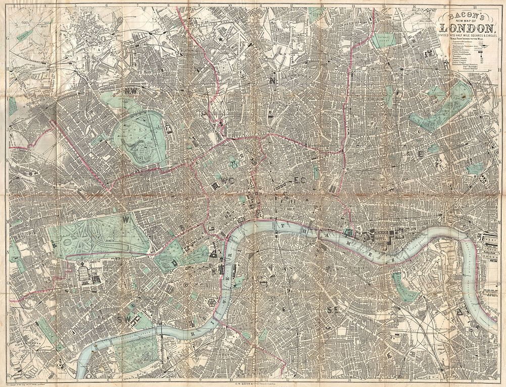
English: An extremely attractive c. 1890 traveler's pocket map of Victorian London, England. Covers central London on a scale of four inches to the mile - from West Kensington in the west across to the West India Docks in the east, and from Hampstead down to North Brixton and Camberwell. Offers extraordinary detail throughout noting streets, trains, ferries, docks, and important buildings. Parks are particularly well produced with superb detail on the interior. Concentric circles radiate out from Charing Cross to indicate half mile distances from the city center. Published by George Washington Bacon of 127 Strand, London. |
||||||||||||||||
| Date | 1890 (undated) | ||||||||||||||||
| Dimensions | height: 25 in (63.5 cm); width: 33 in (83.8 cm) | ||||||||||||||||
| Accession number |
Geographicus link: London-bacon-1890 |
||||||||||||||||
| Source/Photographer |
Bacon, G. W., Bacon's New Shilling Map of London and Illustrated Guide. With a Large Scale Plan of the City, A Railway Map of the Environs. Street Directory, Cab Fares, & Co. , 1890.
|
||||||||||||||||
| Permission (Reusing this file) |
|
||||||||||||||||
| Other versions | |||||||||||||||||
.jpg)
File history
Click on a date/time to view the file as it appeared at that time.
| Date/Time | Thumbnail | Dimensions | User | Comment | |
|---|---|---|---|---|---|
| current | 17:08, 23 March 2011 | | 6,000 × 4,598 (11.4 MB) | BotMultichillT | {{subst:User:Multichill/Geographicus |link=http://www.geographicus.com/P/AntiqueMap/London-bacon-1890 |product_name=1890 Bacon Traveler's Pocket Map of London, England |map_title=Bacon's New Map of London Divided into Half Mile Squares & Circles. |descrip |
File usage
The following pages on the English Wikipedia use this file (pages on other projects are not listed):